You are here: Home > Network List > AK - Alaska Regional Network Stations List
> Station CYK Cape Yakataga, AK, USA > Earthquake Result Viewer
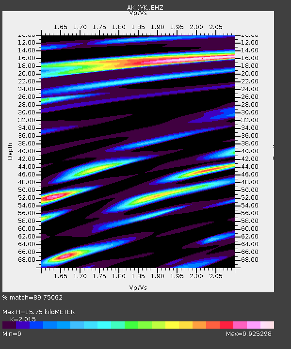
CYK Cape Yakataga, AK, USA - Earthquake Result Viewer
| Earthquake location: |
Solomon Islands |
| Earthquake latitude/longitude: |
-7.3/154.5 |
| Earthquake time(UTC): |
2015/05/07 (127) 07:10:22 GMT |
| Earthquake Depth: |
22 km |
| Earthquake Magnitude: |
7.2 MWP, 7.2 MI |
| Earthquake Catalog/Contributor: |
NEIC PDE/NEIC COMCAT |
|
| Network: |
AK Alaska Regional Network |
| Station: |
CYK Cape Yakataga, AK, USA |
| Lat/Lon: |
60.08 N/142.49 W |
| Elevation: |
23 m |
|
| Distance: |
83.3 deg |
| Az: |
26.721 deg |
| Baz: |
242.857 deg |
| Ray Param: |
0.04628012 |
| Estimated Moho Depth: |
15.75 km |
| Estimated Crust Vp/Vs: |
2.02 |
| Assumed Crust Vp: |
6.566 km/s |
| Estimated Crust Vs: |
3.259 km/s |
| Estimated Crust Poisson's Ratio: |
0.34 |
|
| Radial Match: |
89.75062 % |
| Radial Bump: |
400 |
| Transverse Match: |
73.36977 % |
| Transverse Bump: |
400 |
| SOD ConfigId: |
7422571 |
| Insert Time: |
2019-04-18 17:19:16.092 +0000 |
| GWidth: |
2.5 |
| Max Bumps: |
400 |
| Tol: |
0.001 |
|

Signal To Noise
| Channel | StoN | STA | LTA |
| AK:CYK: :BHZ:20150507T07:22:15.527971Z | 7.559588 | 2.317546E-6 | 3.065704E-7 |
| AK:CYK: :BHN:20150507T07:22:15.527971Z | 1.0863343 | 4.374692E-7 | 4.027022E-7 |
| AK:CYK: :BHE:20150507T07:22:15.527971Z | 2.8103244 | 9.670377E-7 | 3.441018E-7 |
| Arrivals |
| Ps | 2.5 SECOND |
| PpPs | 7.1 SECOND |
| PsPs/PpSs | 9.6 SECOND |


