You are here: Home > Network List > AK - Alaska Regional Network Stations List
> Station DIV Divide Microwave > Earthquake Result Viewer
DIV Divide Microwave - Earthquake Result Viewer
| Earthquake location: |
Solomon Islands |
| Earthquake latitude/longitude: |
-7.3/154.5 |
| Earthquake time(UTC): |
2015/05/07 (127) 07:10:22 GMT |
| Earthquake Depth: |
22 km |
| Earthquake Magnitude: |
7.2 MWP, 7.2 MI |
| Earthquake Catalog/Contributor: |
NEIC PDE/NEIC COMCAT |
|
| Network: |
AK Alaska Regional Network |
| Station: |
DIV Divide Microwave |
| Lat/Lon: |
61.13 N/145.77 W |
| Elevation: |
939 m |
|
| Distance: |
82.4 deg |
| Az: |
25.008 deg |
| Baz: |
239.785 deg |
| Ray Param: |
0.046919107 |
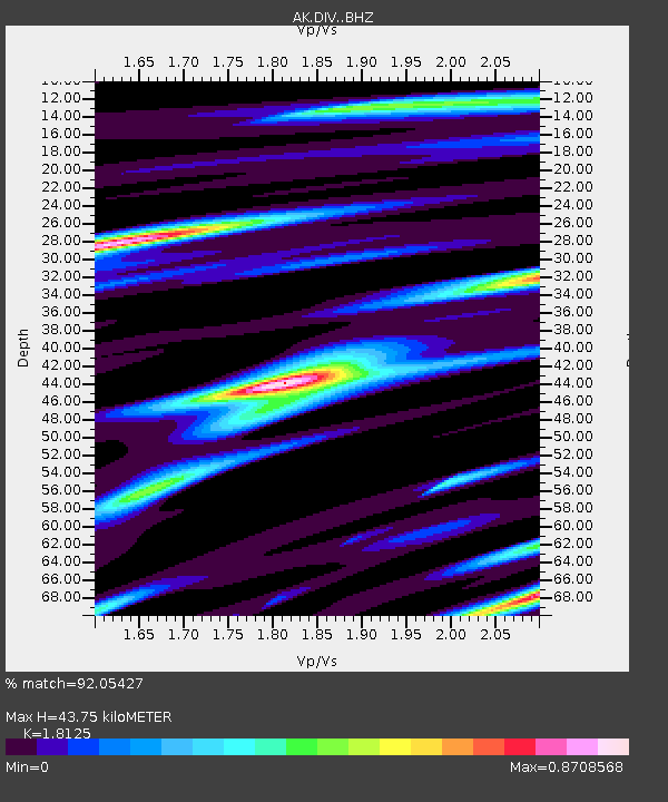
| Estimated Moho Depth: |
43.75 km |
| Estimated Crust Vp/Vs: |
1.81 |
| Assumed Crust Vp: |
6.566 km/s |
| Estimated Crust Vs: |
3.623 km/s |
| Estimated Crust Poisson's Ratio: |
0.28 |
|
| Radial Match: |
92.05427 % |
| Radial Bump: |
400 |
| Transverse Match: |
83.80851 % |
| Transverse Bump: |
400 |
| SOD ConfigId: |
7422571 |
| Insert Time: |
2019-04-18 17:19:17.955 +0000 |
| GWidth: |
2.5 |
| Max Bumps: |
400 |
| Tol: |
0.001 |
|

Signal To Noise
| Channel | StoN | STA | LTA |
| AK:DIV: :BHZ:20150507T07:22:10.787981Z | 17.21081 | 2.3566608E-6 | 1.3692912E-7 |
| AK:DIV: :BHN:20150507T07:22:10.787981Z | 3.314502 | 5.015845E-7 | 1.5133027E-7 |
| AK:DIV: :BHE:20150507T07:22:10.787981Z | 6.9315677 | 8.203708E-7 | 1.1835285E-7 |
| Arrivals |
| Ps | 5.6 SECOND |
| PpPs | 18 SECOND |
| PsPs/PpSs | 24 SECOND |


