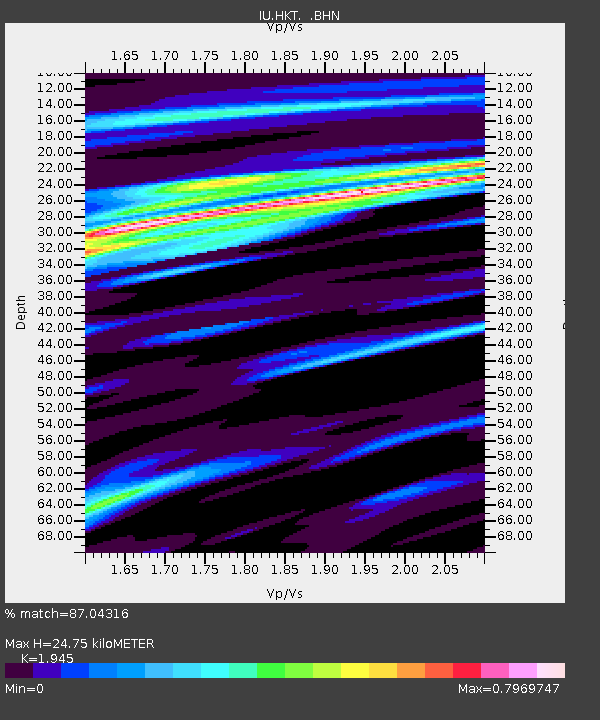
HKT Hockley, Texas - Earthquake Result Viewer
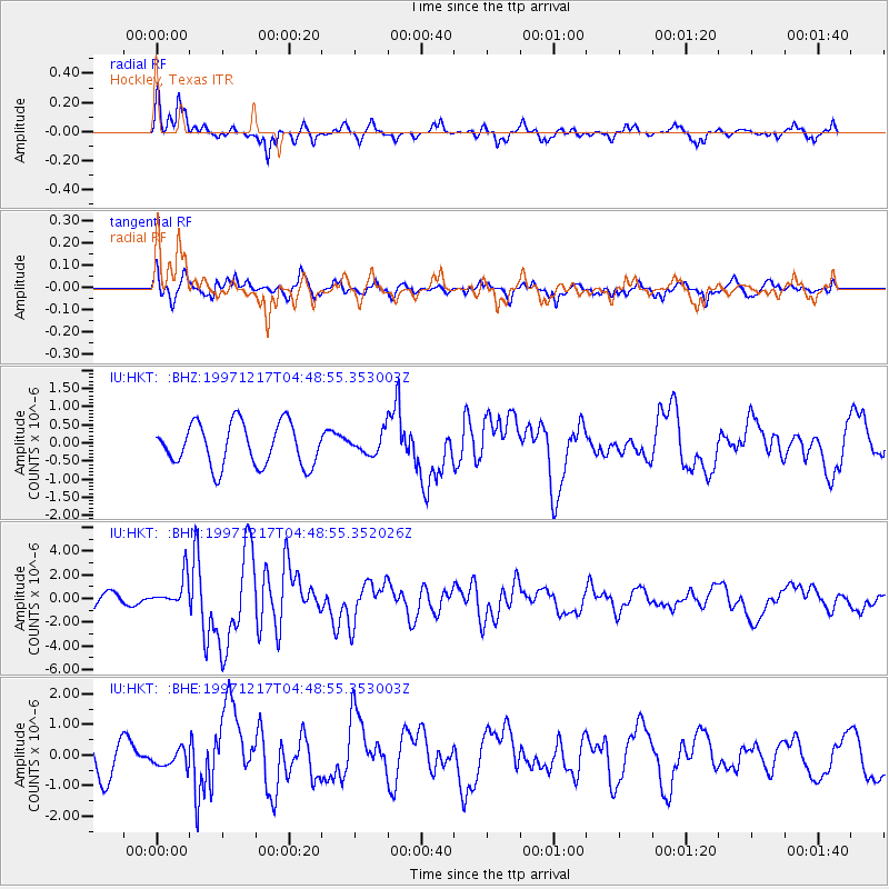
Earthquake location: Rat Islands, Aleutian Islands
Earthquake latitude/longitude: 51.2/178.9
Earthquake time(UTC): 1997/12/17 (351) 04:38:51 GMT
Earthquake Depth: 20 km
Earthquake Magnitude: 5.8 MB, 6.5 MS, 6.7 UNKNOWN, 6.1 ME
Earthquake Catalog/Contributor: WHDF/NEIC
Network: IU Global Seismograph Network (GSN - IRIS/USGS)
Station: HKT Hockley, Texas
Lat/Lon: 29.96 N/95.84 W
Elevation: -413.0 m
Distance: 64.5 deg
Az: 73.429 deg
Baz: 315.966 deg
Ray Param: 0.058881186
Estimated Moho Depth: 24.75 km
Estimated Crust Vp/Vs: 1.95
Assumed Crust Vp: 5.581 km/s
Estimated Crust Vs: 2.87 km/s
Estimated Crust Poisson's Ratio: 0.32
Radial Match: 87.04316 %
Radial Bump: 345
Transverse Match: 48.290718 %
Transverse Bump: 400
SOD ConfigId: 4480
Insert Time: 2010-03-02 13:50:21.202 +0000
GWidth: 2.5
Max Bumps: 400
Tol: 0.001

Signal To Noise

ChannelStoNSTALTA
IU:HKT: :BHN:19971217T04:48:55.352026Z2.18490121.267111E-65.7993975E-7
IU:HKT: :BHE:19971217T04:48:55.353003Z0.377681552.775571E-77.348972E-7
IU:HKT: :BHZ:19971217T04:48:55.353003Z0.484966252.8155605E-75.805684E-7
Arrivals
Ps4.3 SECOND
PpPs13 SECOND
PsPs/PpSs17 SECOND