You are here: Home > Network List > AK - Alaska Regional Network Stations List
> Station FYU Fort Yukon, Alaska, USA > Earthquake Result Viewer
FYU Fort Yukon, Alaska, USA - Earthquake Result Viewer
| Earthquake location: |
Solomon Islands |
| Earthquake latitude/longitude: |
-7.3/154.5 |
| Earthquake time(UTC): |
2015/05/07 (127) 07:10:22 GMT |
| Earthquake Depth: |
22 km |
| Earthquake Magnitude: |
7.2 MWP, 7.2 MI |
| Earthquake Catalog/Contributor: |
NEIC PDE/NEIC COMCAT |
|
| Network: |
AK Alaska Regional Network |
| Station: |
FYU Fort Yukon, Alaska, USA |
| Lat/Lon: |
66.57 N/145.23 W |
| Elevation: |
137 m |
|
| Distance: |
85.3 deg |
| Az: |
20.386 deg |
| Baz: |
239.774 deg |
| Ray Param: |
0.044829704 |
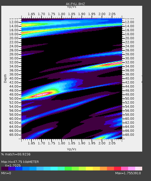
| Estimated Moho Depth: |
47.75 km |
| Estimated Crust Vp/Vs: |
1.70 |
| Assumed Crust Vp: |
6.522 km/s |
| Estimated Crust Vs: |
3.831 km/s |
| Estimated Crust Poisson's Ratio: |
0.24 |
|
| Radial Match: |
88.9236 % |
| Radial Bump: |
315 |
| Transverse Match: |
77.8433 % |
| Transverse Bump: |
318 |
| SOD ConfigId: |
7422571 |
| Insert Time: |
2019-04-18 17:19:21.836 +0000 |
| GWidth: |
2.5 |
| Max Bumps: |
400 |
| Tol: |
0.001 |
|

Signal To Noise
| Channel | StoN | STA | LTA |
| AK:FYU: :BHZ:20150507T07:22:25.82802Z | 18.442743 | 1.7201226E-6 | 9.326826E-8 |
| AK:FYU: :BHN:20150507T07:22:25.82802Z | 1.7262293 | 5.36281E-7 | 3.1066614E-7 |
| AK:FYU: :BHE:20150507T07:22:25.82802Z | 1.4344457 | 4.058614E-7 | 2.8293954E-7 |
| Arrivals |
| Ps | 5.3 SECOND |
| PpPs | 19 SECOND |
| PsPs/PpSs | 25 SECOND |


