You are here: Home > Network List > IU - Global Seismograph Network (GSN - IRIS/USGS) Stations List
> Station HKT Hockley, Texas > Earthquake Result Viewer
HKT Hockley, Texas - Earthquake Result Viewer
| Earthquake location: |
Western Brazil |
| Earthquake latitude/longitude: |
-8.2/-71.6 |
| Earthquake time(UTC): |
2003/04/27 (117) 22:57:44 GMT |
| Earthquake Depth: |
560 km |
| Earthquake Magnitude: |
5.6 MB, 6.0 MW, 5.9 MW |
| Earthquake Catalog/Contributor: |
WHDF/NEIC |
|
| Network: |
IU Global Seismograph Network (GSN - IRIS/USGS) |
| Station: |
HKT Hockley, Texas |
| Lat/Lon: |
29.96 N/95.84 W |
| Elevation: |
-413.0 m |
|
| Distance: |
44.5 deg |
| Az: |
329.456 deg |
| Baz: |
144.57 deg |
| Ray Param: |
0.069117025 |
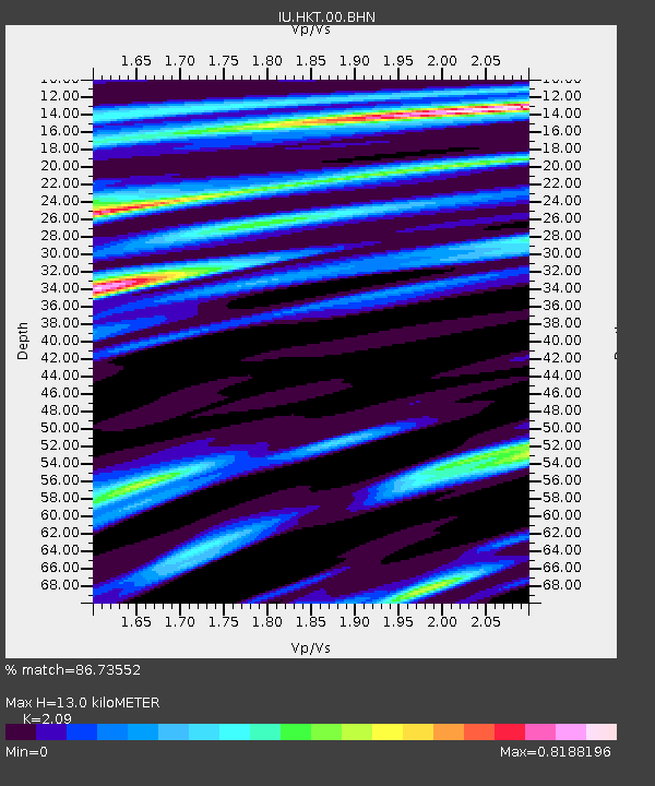
| Estimated Moho Depth: |
13.0 km |
| Estimated Crust Vp/Vs: |
2.09 |
| Assumed Crust Vp: |
5.581 km/s |
| Estimated Crust Vs: |
2.671 km/s |
| Estimated Crust Poisson's Ratio: |
0.35 |
|
| Radial Match: |
86.73552 % |
| Radial Bump: |
400 |
| Transverse Match: |
71.145454 % |
| Transverse Bump: |
400 |
| SOD ConfigId: |
4714 |
| Insert Time: |
2010-03-02 13:50:28.945 +0000 |
| GWidth: |
2.5 |
| Max Bumps: |
400 |
| Tol: |
0.001 |
|
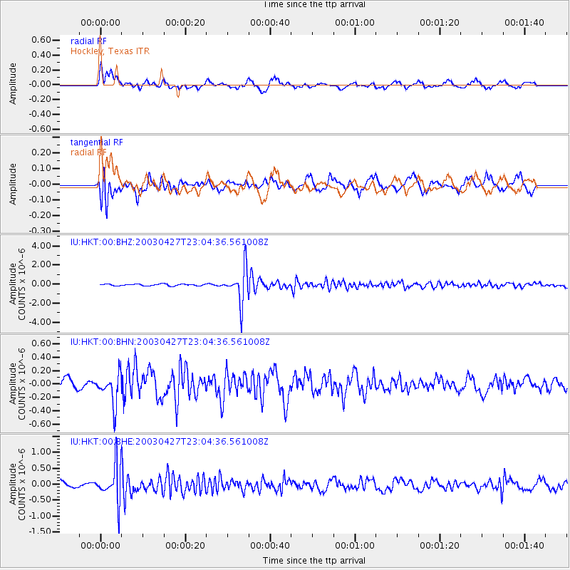
Signal To Noise
| Channel | StoN | STA | LTA |
| IU:HKT:00:BHN:20030427T23:04:36.561008Z | 2.9939961 | 2.3391904E-7 | 7.8129375E-8 |
| IU:HKT:00:BHE:20030427T23:04:36.561008Z | 4.4660664 | 5.9138443E-7 | 1.324173E-7 |
| IU:HKT:00:BHZ:20030427T23:04:36.561008Z | 21.00296 | 1.8614907E-6 | 8.8629925E-8 |
| Arrivals |
| Ps | 2.6 SECOND |
| PpPs | 6.9 SECOND |
| PsPs/PpSs | 9.6 SECOND |


