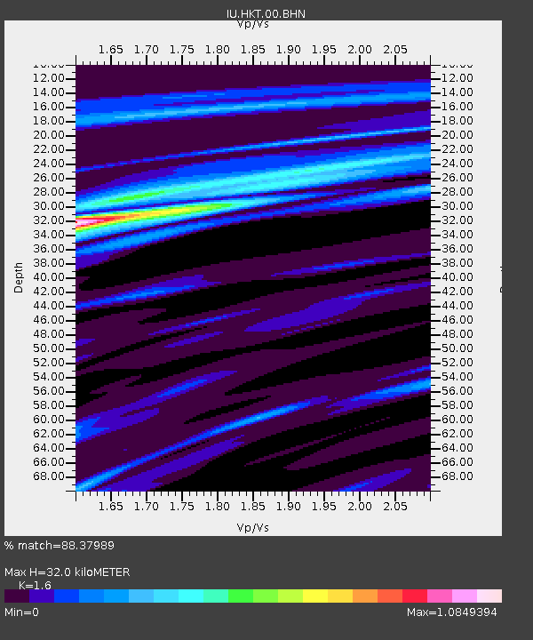
HKT Hockley, Texas - Earthquake Result Viewer
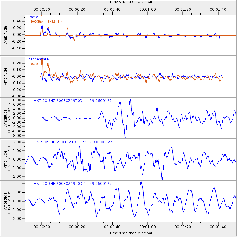
Earthquake location: Unimak Island Region, Alaska
Earthquake latitude/longitude: 53.6/-164.6
Earthquake time(UTC): 2003/02/19 (050) 03:32:36 GMT
Earthquake Depth: 19 km
Earthquake Magnitude: 5.8 MB, 6.6 MS, 6.6 MW, 6.6 MW
Earthquake Catalog/Contributor: WHDF/NEIC
Network: IU Global Seismograph Network (GSN - IRIS/USGS)
Station: HKT Hockley, Texas
Lat/Lon: 29.96 N/95.84 W
Elevation: -413.0 m
Distance: 54.1 deg
Az: 86.904 deg
Baz: 316.759 deg
Ray Param: 0.06562341
Estimated Moho Depth: 32.0 km
Estimated Crust Vp/Vs: 1.60
Assumed Crust Vp: 5.581 km/s
Estimated Crust Vs: 3.488 km/s
Estimated Crust Poisson's Ratio: 0.18
Radial Match: 88.37989 %
Radial Bump: 370
Transverse Match: 69.95844 %
Transverse Bump: 391
SOD ConfigId: 4714
Insert Time: 2010-03-02 13:50:32.471 +0000
GWidth: 2.5
Max Bumps: 400
Tol: 0.001

Signal To Noise

ChannelStoNSTALTA
IU:HKT:00:BHN:20030219T03:41:29.060012Z0.72992334.5031157E-76.1693E-7
IU:HKT:00:BHE:20030219T03:41:29.060012Z1.07074811.8996434E-71.7741273E-7
IU:HKT:00:BHZ:20030219T03:41:29.060012Z2.87598561.3235662E-64.6021304E-7
Arrivals
Ps3.6 SECOND
PpPs14 SECOND
PsPs/PpSs18 SECOND