You are here: Home > Network List > AK - Alaska Regional Network Stations List
> Station WAT3 Susitna Watana 3, AK, USA > Earthquake Result Viewer
WAT3 Susitna Watana 3, AK, USA - Earthquake Result Viewer
| Earthquake location: |
Solomon Islands |
| Earthquake latitude/longitude: |
-7.3/154.5 |
| Earthquake time(UTC): |
2015/05/07 (127) 07:10:22 GMT |
| Earthquake Depth: |
22 km |
| Earthquake Magnitude: |
7.2 MWP, 7.2 MI |
| Earthquake Catalog/Contributor: |
NEIC PDE/NEIC COMCAT |
|
| Network: |
AK Alaska Regional Network |
| Station: |
WAT3 Susitna Watana 3, AK, USA |
| Lat/Lon: |
62.68 N/148.54 W |
| Elevation: |
1500 m |
|
| Distance: |
82.1 deg |
| Az: |
22.977 deg |
| Baz: |
237.074 deg |
| Ray Param: |
0.047126967 |
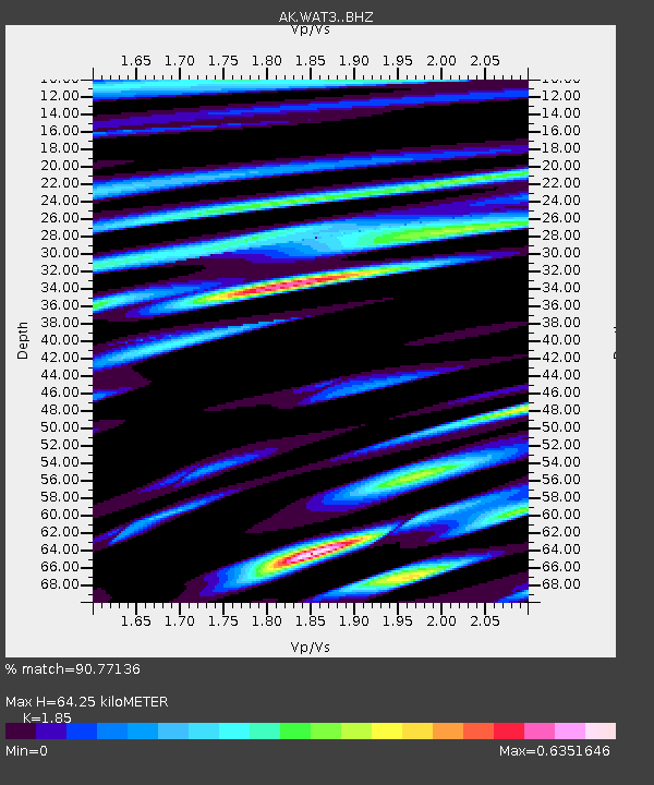
| Estimated Moho Depth: |
64.25 km |
| Estimated Crust Vp/Vs: |
1.85 |
| Assumed Crust Vp: |
6.566 km/s |
| Estimated Crust Vs: |
3.549 km/s |
| Estimated Crust Poisson's Ratio: |
0.29 |
|
| Radial Match: |
90.77136 % |
| Radial Bump: |
400 |
| Transverse Match: |
79.45292 % |
| Transverse Bump: |
400 |
| SOD ConfigId: |
7422571 |
| Insert Time: |
2019-04-18 17:20:08.868 +0000 |
| GWidth: |
2.5 |
| Max Bumps: |
400 |
| Tol: |
0.001 |
|

Signal To Noise
| Channel | StoN | STA | LTA |
| AK:WAT3: :BHZ:20150507T07:22:09.227983Z | 23.581314 | 1.9303689E-6 | 8.186011E-8 |
| AK:WAT3: :BHN:20150507T07:22:09.227983Z | 5.419659 | 5.771653E-7 | 1.0649476E-7 |
| AK:WAT3: :BHE:20150507T07:22:09.227983Z | 3.1252449 | 6.167629E-7 | 1.9734867E-7 |
| Arrivals |
| Ps | 8.5 SECOND |
| PpPs | 27 SECOND |
| PsPs/PpSs | 36 SECOND |


