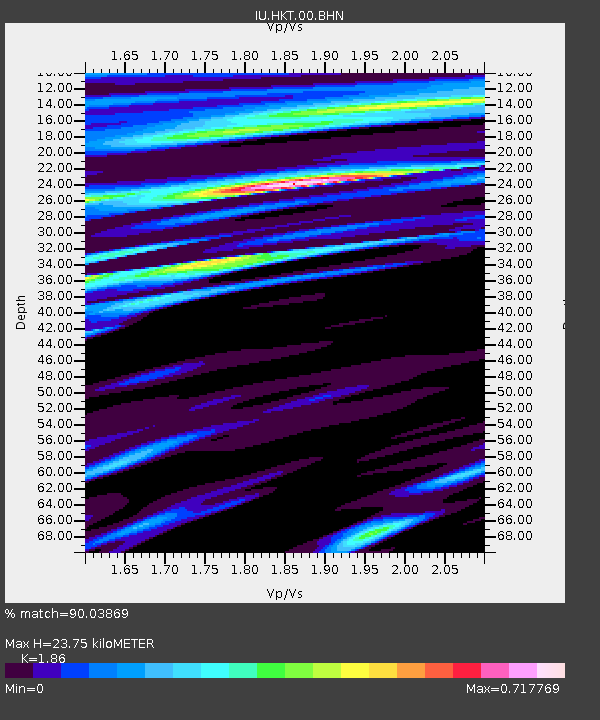
HKT Hockley, Texas - Earthquake Result Viewer
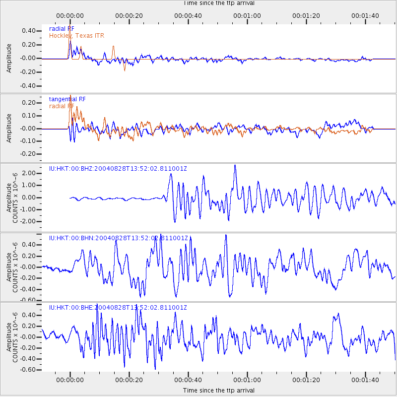
Earthquake location: Chile-Argentina Border Region
Earthquake latitude/longitude: -34.9/-70.4
Earthquake time(UTC): 2004/08/28 (241) 13:41:27 GMT
Earthquake Depth: 1.0 km
Earthquake Magnitude: 6.1 MB, 6.3 MS, 6.5 MW, 6.5 MW
Earthquake Catalog/Contributor: WHDF/NEIC
Network: IU Global Seismograph Network (GSN - IRIS/USGS)
Station: HKT Hockley, Texas
Lat/Lon: 29.96 N/95.84 W
Elevation: -413.0 m
Distance: 68.9 deg
Az: 336.432 deg
Baz: 157.755 deg
Ray Param: 0.056043472
Estimated Moho Depth: 23.75 km
Estimated Crust Vp/Vs: 1.86
Assumed Crust Vp: 5.581 km/s
Estimated Crust Vs: 3.001 km/s
Estimated Crust Poisson's Ratio: 0.30
Radial Match: 90.03869 %
Radial Bump: 380
Transverse Match: 59.767193 %
Transverse Bump: 400
SOD ConfigId: 2459
Insert Time: 2010-03-02 13:50:49.775 +0000
GWidth: 2.5
Max Bumps: 400
Tol: 0.001

Signal To Noise

ChannelStoNSTALTA
IU:HKT:00:BHN:20040828T13:52:02.811001Z3.43969851.6364721E-74.7576034E-8
IU:HKT:00:BHE:20040828T13:52:02.811001Z1.10141462.0367186E-71.8491843E-7
IU:HKT:00:BHZ:20040828T13:52:02.811001Z11.8963668.3697915E-77.035587E-8
Arrivals
Ps3.8 SECOND
PpPs12 SECOND
PsPs/PpSs16 SECOND