You are here: Home > Network List > AT - Alaska Tsunami Warning Seismic System Stations List
> Station OHAK Old Harbor, Alaska > Earthquake Result Viewer
OHAK Old Harbor, Alaska - Earthquake Result Viewer
| Earthquake location: |
Solomon Islands |
| Earthquake latitude/longitude: |
-7.3/154.5 |
| Earthquake time(UTC): |
2015/05/07 (127) 07:10:22 GMT |
| Earthquake Depth: |
22 km |
| Earthquake Magnitude: |
7.2 MWP, 7.2 MI |
| Earthquake Catalog/Contributor: |
NEIC PDE/NEIC COMCAT |
|
| Network: |
AT Alaska Tsunami Warning Seismic System |
| Station: |
OHAK Old Harbor, Alaska |
| Lat/Lon: |
57.22 N/153.29 W |
| Elevation: |
78 m |
|
| Distance: |
77.0 deg |
| Az: |
26.169 deg |
| Baz: |
233.545 deg |
| Ray Param: |
0.050608225 |
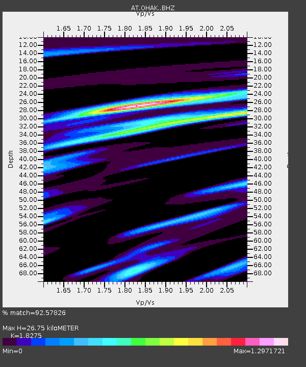
| Estimated Moho Depth: |
26.75 km |
| Estimated Crust Vp/Vs: |
1.83 |
| Assumed Crust Vp: |
6.134 km/s |
| Estimated Crust Vs: |
3.356 km/s |
| Estimated Crust Poisson's Ratio: |
0.29 |
|
| Radial Match: |
92.57826 % |
| Radial Bump: |
400 |
| Transverse Match: |
80.95736 % |
| Transverse Bump: |
400 |
| SOD ConfigId: |
7422571 |
| Insert Time: |
2019-04-18 17:20:15.447 +0000 |
| GWidth: |
2.5 |
| Max Bumps: |
400 |
| Tol: |
0.001 |
|

Signal To Noise
| Channel | StoN | STA | LTA |
| AT:OHAK: :BHZ:20150507T07:21:41.700029Z | 4.568392 | 2.3346588E-6 | 5.110461E-7 |
| AT:OHAK: :BHN:20150507T07:21:41.700029Z | 0.88921386 | 5.255745E-7 | 5.910552E-7 |
| AT:OHAK: :BHE:20150507T07:21:41.700029Z | 2.095207 | 1.2821414E-6 | 6.1194027E-7 |
| Arrivals |
| Ps | 3.7 SECOND |
| PpPs | 12 SECOND |
| PsPs/PpSs | 16 SECOND |


