You are here: Home > Network List > AU - Australian Seismological Centre Stations List
> Station MEEK Meekatharra, Western Australia > Earthquake Result Viewer
MEEK Meekatharra, Western Australia - Earthquake Result Viewer
| Earthquake location: |
Solomon Islands |
| Earthquake latitude/longitude: |
-7.3/154.5 |
| Earthquake time(UTC): |
2015/05/07 (127) 07:10:22 GMT |
| Earthquake Depth: |
22 km |
| Earthquake Magnitude: |
7.2 MWP, 7.2 MI |
| Earthquake Catalog/Contributor: |
NEIC PDE/NEIC COMCAT |
|
| Network: |
AU Australian Seismological Centre |
| Station: |
MEEK Meekatharra, Western Australia |
| Lat/Lon: |
26.64 S/118.61 E |
| Elevation: |
530 m |
|
| Distance: |
39.2 deg |
| Az: |
236.224 deg |
| Baz: |
67.116 deg |
| Ray Param: |
0.075104244 |
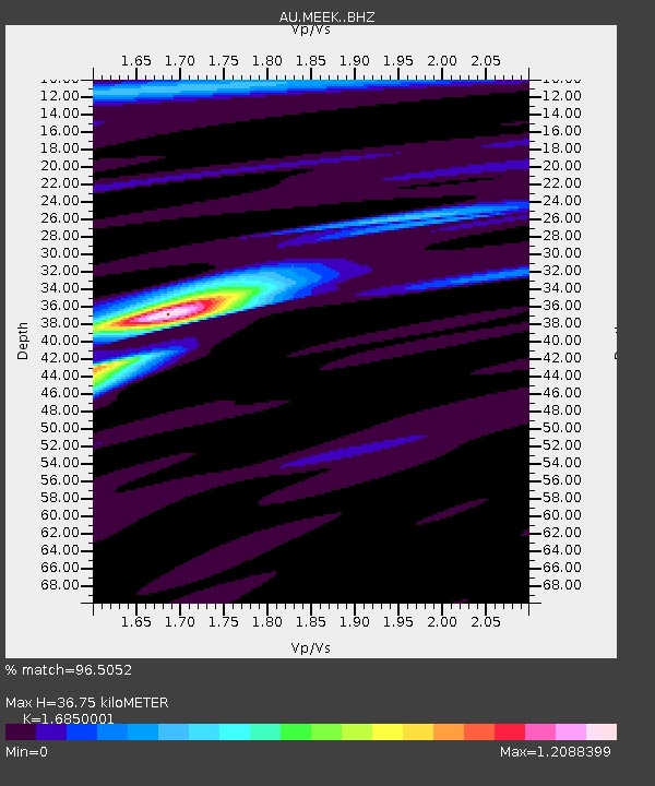
| Estimated Moho Depth: |
36.75 km |
| Estimated Crust Vp/Vs: |
1.69 |
| Assumed Crust Vp: |
6.459 km/s |
| Estimated Crust Vs: |
3.834 km/s |
| Estimated Crust Poisson's Ratio: |
0.23 |
|
| Radial Match: |
96.5052 % |
| Radial Bump: |
242 |
| Transverse Match: |
91.167336 % |
| Transverse Bump: |
371 |
| SOD ConfigId: |
7422571 |
| Insert Time: |
2019-04-18 17:20:26.515 +0000 |
| GWidth: |
2.5 |
| Max Bumps: |
400 |
| Tol: |
0.001 |
|

Signal To Noise
| Channel | StoN | STA | LTA |
| AU:MEEK: :BHZ:20150507T07:17:17.619005Z | 3.0279214 | 1.5069372E-6 | 4.9768045E-7 |
| AU:MEEK: :BHN:20150507T07:17:17.619005Z | 0.9076735 | 3.6973506E-7 | 4.073437E-7 |
| AU:MEEK: :BHE:20150507T07:17:17.619005Z | 2.4893048 | 6.772639E-7 | 2.7206949E-7 |
| Arrivals |
| Ps | 4.2 SECOND |
| PpPs | 14 SECOND |
| PsPs/PpSs | 18 SECOND |


