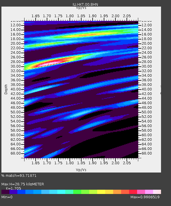
HKT Hockley, Texas - Earthquake Result Viewer
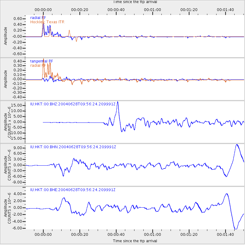
Earthquake location: Queen Charlotte Islands Region
Earthquake latitude/longitude: 54.8/-134.2
Earthquake time(UTC): 2004/06/28 (180) 09:49:47 GMT
Earthquake Depth: 20 km
Earthquake Magnitude: 5.9 MB, 6.8 MS, 6.8 MW, 6.8 MW
Earthquake Catalog/Contributor: WHDF/NEIC
Network: IU Global Seismograph Network (GSN - IRIS/USGS)
Station: HKT Hockley, Texas
Lat/Lon: 29.96 N/95.84 W
Elevation: -413.0 m
Distance: 37.0 deg
Az: 116.318 deg
Baz: 323.269 deg
Ray Param: 0.076361686
Estimated Moho Depth: 28.75 km
Estimated Crust Vp/Vs: 1.71
Assumed Crust Vp: 5.581 km/s
Estimated Crust Vs: 3.274 km/s
Estimated Crust Poisson's Ratio: 0.24
Radial Match: 93.71871 %
Radial Bump: 212
Transverse Match: 77.4461 %
Transverse Bump: 379
SOD ConfigId: 2459
Insert Time: 2010-03-02 13:51:08.799 +0000
GWidth: 2.5
Max Bumps: 400
Tol: 0.001

Signal To Noise

ChannelStoNSTALTA
IU:HKT:00:BHN:20040628T09:56:24.209991Z2.79484253.034911E-71.08589695E-7
IU:HKT:00:BHE:20040628T09:56:24.209991Z3.06472641.9289045E-76.293888E-8
IU:HKT:00:BHZ:20040628T09:56:24.209991Z8.311726.9337625E-78.342152E-8
Arrivals
Ps3.8 SECOND
PpPs13 SECOND
PsPs/PpSs17 SECOND