You are here: Home > Network List > AZ - ANZA Regional Network Stations List
> Station RRSP RRSP, CA, USA > Earthquake Result Viewer
RRSP RRSP, CA, USA - Earthquake Result Viewer
| Earthquake location: |
Solomon Islands |
| Earthquake latitude/longitude: |
-7.3/154.5 |
| Earthquake time(UTC): |
2015/05/07 (127) 07:10:22 GMT |
| Earthquake Depth: |
22 km |
| Earthquake Magnitude: |
7.2 MWP, 7.2 MI |
| Earthquake Catalog/Contributor: |
NEIC PDE/NEIC COMCAT |
|
| Network: |
AZ ANZA Regional Network |
| Station: |
RRSP RRSP, CA, USA |
| Lat/Lon: |
33.65 N/116.74 W |
| Elevation: |
1610 m |
|
| Distance: |
92.9 deg |
| Az: |
56.617 deg |
| Baz: |
263.265 deg |
| Ray Param: |
0.041356925 |
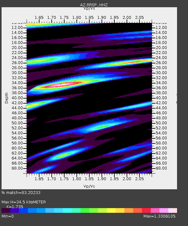
| Estimated Moho Depth: |
34.5 km |
| Estimated Crust Vp/Vs: |
1.74 |
| Assumed Crust Vp: |
6.264 km/s |
| Estimated Crust Vs: |
3.61 km/s |
| Estimated Crust Poisson's Ratio: |
0.25 |
|
| Radial Match: |
83.20233 % |
| Radial Bump: |
400 |
| Transverse Match: |
77.23732 % |
| Transverse Bump: |
400 |
| SOD ConfigId: |
7422571 |
| Insert Time: |
2019-04-18 17:20:52.399 +0000 |
| GWidth: |
2.5 |
| Max Bumps: |
400 |
| Tol: |
0.001 |
|

Signal To Noise
| Channel | StoN | STA | LTA |
| AZ:RRSP: :HHZ:20150507T07:23:01.654009Z | 3.1446345 | 6.776131E-7 | 2.1548232E-7 |
| AZ:RRSP: :HHN:20150507T07:23:01.654009Z | 1.7172257 | 4.7659648E-7 | 2.7753865E-7 |
| AZ:RRSP: :HHE:20150507T07:23:01.654009Z | 1.0999763 | 3.7483517E-7 | 3.4076658E-7 |
| Arrivals |
| Ps | 4.1 SECOND |
| PpPs | 15 SECOND |
| PsPs/PpSs | 19 SECOND |


