You are here: Home > Network List > IU - Global Seismograph Network (GSN - IRIS/USGS) Stations List
> Station HKT Hockley, Texas > Earthquake Result Viewer
HKT Hockley, Texas - Earthquake Result Viewer
| Earthquake location: |
Tonga Islands |
| Earthquake latitude/longitude: |
-16.8/-174.2 |
| Earthquake time(UTC): |
2004/01/25 (025) 11:43:11 GMT |
| Earthquake Depth: |
130 km |
| Earthquake Magnitude: |
6.4 MB, 6.7 MW, 6.7 MW |
| Earthquake Catalog/Contributor: |
WHDF/NEIC |
|
| Network: |
IU Global Seismograph Network (GSN - IRIS/USGS) |
| Station: |
HKT Hockley, Texas |
| Lat/Lon: |
29.96 N/95.84 W |
| Elevation: |
-413.0 m |
|
| Distance: |
88.6 deg |
| Az: |
58.235 deg |
| Baz: |
249.766 deg |
| Ray Param: |
0.042197824 |
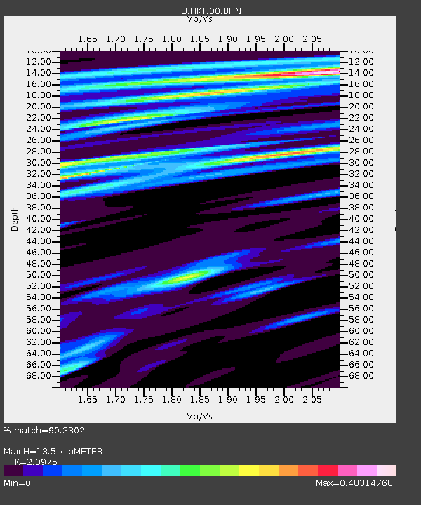
| Estimated Moho Depth: |
13.5 km |
| Estimated Crust Vp/Vs: |
2.10 |
| Assumed Crust Vp: |
5.581 km/s |
| Estimated Crust Vs: |
2.661 km/s |
| Estimated Crust Poisson's Ratio: |
0.35 |
|
| Radial Match: |
90.3302 % |
| Radial Bump: |
398 |
| Transverse Match: |
84.8053 % |
| Transverse Bump: |
400 |
| SOD ConfigId: |
2459 |
| Insert Time: |
2010-03-02 13:51:18.317 +0000 |
| GWidth: |
2.5 |
| Max Bumps: |
400 |
| Tol: |
0.001 |
|
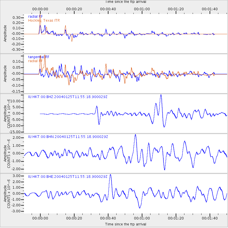
Signal To Noise
| Channel | StoN | STA | LTA |
| IU:HKT:00:BHN:20040125T11:55:18.900029Z | 1.3770959 | 3.36938E-7 | 2.4467286E-7 |
| IU:HKT:00:BHE:20040125T11:55:18.900029Z | 1.973919 | 3.9003626E-7 | 1.9759487E-7 |
| IU:HKT:00:BHZ:20040125T11:55:18.900029Z | 17.295576 | 3.4119546E-6 | 1.9727325E-7 |
| Arrivals |
| Ps | 2.7 SECOND |
| PpPs | 7.4 SECOND |
| PsPs/PpSs | 10 SECOND |


