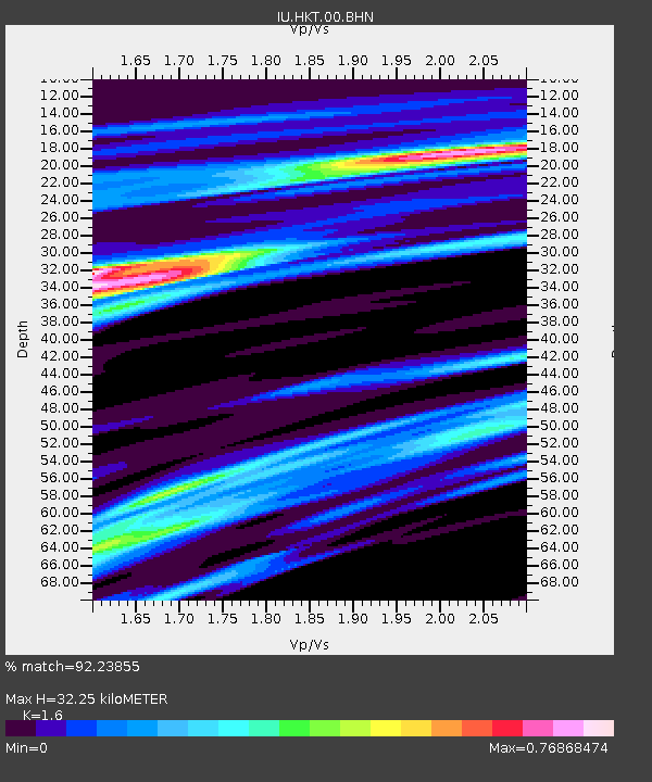
HKT Hockley, Texas - Earthquake Result Viewer

Earthquake location: Andreanof Islands, Aleutian Is.
Earthquake latitude/longitude: 51.9/-179.4
Earthquake time(UTC): 2008/04/15 (106) 22:59:51 GMT
Earthquake Depth: 10 km
Earthquake Magnitude: 6.1 MB, 6.4 MS, 6.4 MW, 6.4 MW
Earthquake Catalog/Contributor: WHDF/NEIC
Network: IU Global Seismograph Network (GSN - IRIS/USGS)
Station: HKT Hockley, Texas
Lat/Lon: 29.96 N/95.84 W
Elevation: -413.0 m
Distance: 63.2 deg
Az: 74.98 deg
Baz: 316.346 deg
Ray Param: 0.059716683
Estimated Moho Depth: 32.25 km
Estimated Crust Vp/Vs: 1.60
Assumed Crust Vp: 5.581 km/s
Estimated Crust Vs: 3.488 km/s
Estimated Crust Poisson's Ratio: 0.18
Radial Match: 92.23855 %
Radial Bump: 386
Transverse Match: 78.68315 %
Transverse Bump: 400
SOD ConfigId: 2504
Insert Time: 2010-03-02 13:51:32.069 +0000
GWidth: 2.5
Max Bumps: 400
Tol: 0.001

Signal To Noise

ChannelStoNSTALTA
IU:HKT:00:BHN:20080415T23:09:48.597009Z10.2754731.4270986E-61.3888398E-7
IU:HKT:00:BHE:20080415T23:09:48.597009Z2.91729163.5470507E-71.2158712E-7
IU:HKT:00:BHZ:20080415T23:09:48.597009Z4.28027252.449746E-75.7233407E-8
Arrivals
Ps3.6 SECOND
PpPs14 SECOND
PsPs/PpSs18 SECOND