You are here: Home > Network List > IU - Global Seismograph Network (GSN - IRIS/USGS) Stations List
> Station HKT Hockley, Texas > Earthquake Result Viewer
HKT Hockley, Texas - Earthquake Result Viewer
| Earthquake location: |
Tonga Islands |
| Earthquake latitude/longitude: |
-20.8/-173.3 |
| Earthquake time(UTC): |
2008/06/26 (178) 21:19:15 GMT |
| Earthquake Depth: |
38 km |
| Earthquake Magnitude: |
6.0 MB, 5.8 MS, 6.2 MW, 6.1 MW |
| Earthquake Catalog/Contributor: |
WHDF/NEIC |
|
| Network: |
IU Global Seismograph Network (GSN - IRIS/USGS) |
| Station: |
HKT Hockley, Texas |
| Lat/Lon: |
29.96 N/95.84 W |
| Elevation: |
-413.0 m |
|
| Distance: |
90.0 deg |
| Az: |
57.913 deg |
| Baz: |
246.013 deg |
| Ray Param: |
0.041701857 |
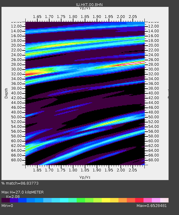
| Estimated Moho Depth: |
27.0 km |
| Estimated Crust Vp/Vs: |
2.08 |
| Assumed Crust Vp: |
5.581 km/s |
| Estimated Crust Vs: |
2.683 km/s |
| Estimated Crust Poisson's Ratio: |
0.35 |
|
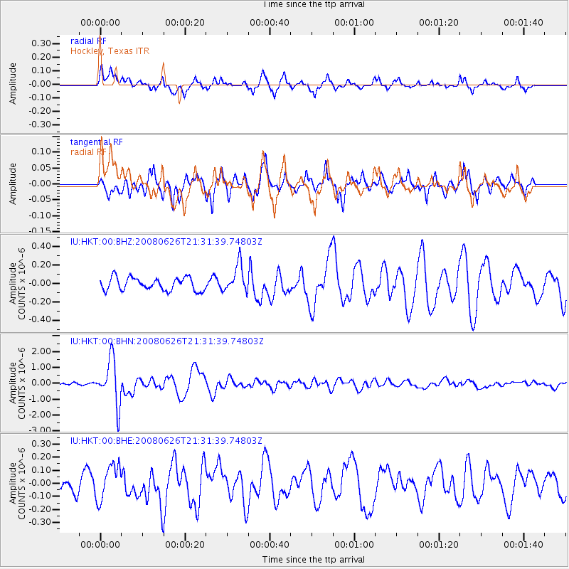
| Radial Match: |
86.83773 % |
| Radial Bump: |
386 |
| Transverse Match: |
81.515686 % |
| Transverse Bump: |
333 |
| SOD ConfigId: |
2504 |
| Insert Time: |
2010-03-02 13:51:39.413 +0000 |
| GWidth: |
2.5 |
| Max Bumps: |
400 |
| Tol: |
0.001 |
|
Signal To Noise
| Channel | StoN | STA | LTA |
| IU:HKT:00:BHN:20080626T21:31:39.74803Z | 21.40519 | 1.4665792E-6 | 6.851513E-8 |
| IU:HKT:00:BHE:20080626T21:31:39.74803Z | 1.6904905 | 1.3609588E-7 | 8.050674E-8 |
| IU:HKT:00:BHZ:20080626T21:31:39.74803Z | 2.2532933 | 1.5470823E-7 | 6.865872E-8 |
| Arrivals |
| Ps | 5.3 SECOND |
| PpPs | 15 SECOND |
| PsPs/PpSs | 20 SECOND |


