You are here: Home > Network List > IU - Global Seismograph Network (GSN - IRIS/USGS) Stations List
> Station HKT Hockley, Texas > Earthquake Result Viewer
HKT Hockley, Texas - Earthquake Result Viewer
| Earthquake location: |
Peru-Brazil Border Region |
| Earthquake latitude/longitude: |
-7.6/-74.4 |
| Earthquake time(UTC): |
2008/08/26 (239) 21:00:36 GMT |
| Earthquake Depth: |
154 km |
| Earthquake Magnitude: |
6.0 MB, 6.4 MW, 6.4 MW |
| Earthquake Catalog/Contributor: |
WHDF/NEIC |
|
| Network: |
IU Global Seismograph Network (GSN - IRIS/USGS) |
| Station: |
HKT Hockley, Texas |
| Lat/Lon: |
29.96 N/95.84 W |
| Elevation: |
-413.0 m |
|
| Distance: |
42.7 deg |
| Az: |
332.083 deg |
| Baz: |
147.67 deg |
| Ray Param: |
0.072438926 |
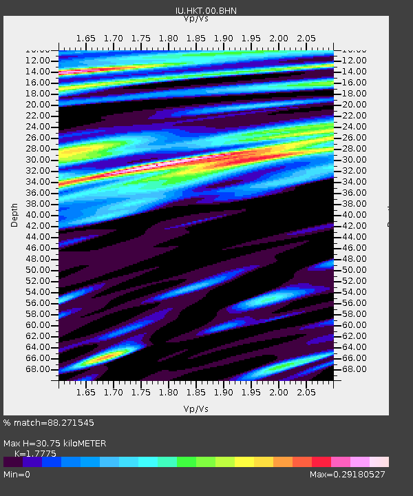
| Estimated Moho Depth: |
30.75 km |
| Estimated Crust Vp/Vs: |
1.78 |
| Assumed Crust Vp: |
5.581 km/s |
| Estimated Crust Vs: |
3.14 km/s |
| Estimated Crust Poisson's Ratio: |
0.27 |
|
| Radial Match: |
88.271545 % |
| Radial Bump: |
400 |
| Transverse Match: |
88.234665 % |
| Transverse Bump: |
379 |
| SOD ConfigId: |
2504 |
| Insert Time: |
2010-03-02 13:51:42.728 +0000 |
| GWidth: |
2.5 |
| Max Bumps: |
400 |
| Tol: |
0.001 |
|
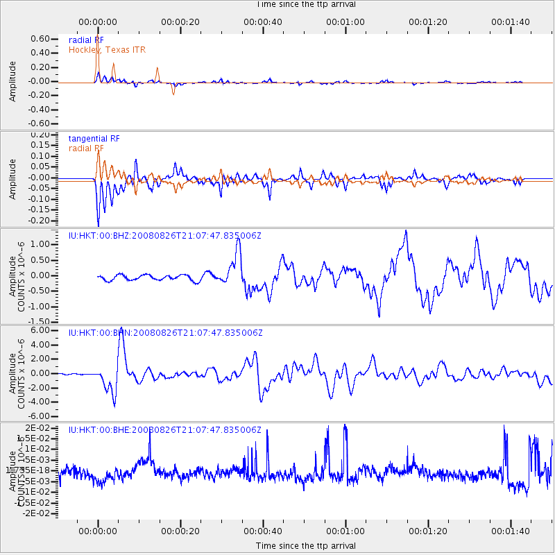
Signal To Noise
| Channel | StoN | STA | LTA |
| IU:HKT:00:BHN:20080826T21:07:47.835006Z | 37.22399 | 1.945963E-6 | 5.2277116E-8 |
| IU:HKT:00:BHE:20080826T21:07:47.835006Z | 1.6152706 | 4.129796E-9 | 2.556721E-9 |
| IU:HKT:00:BHZ:20080826T21:07:47.835006Z | 6.661666 | 5.763898E-7 | 8.652337E-8 |
| Arrivals |
| Ps | 4.5 SECOND |
| PpPs | 15 SECOND |
| PsPs/PpSs | 19 SECOND |


