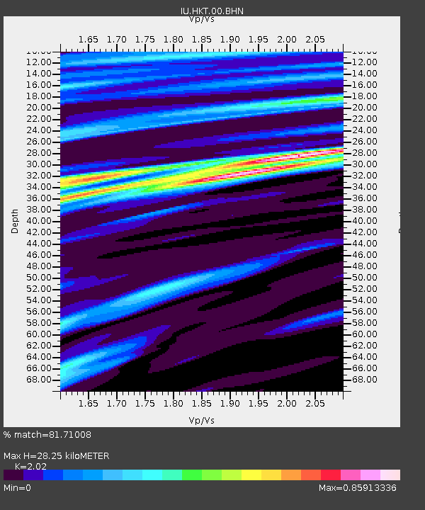
HKT Hockley, Texas - Earthquake Result Viewer
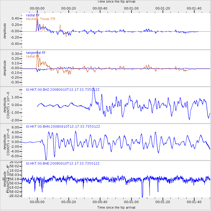
Earthquake location: Central Mid-Atlantic Ridge
Earthquake latitude/longitude: 8.1/-38.7
Earthquake time(UTC): 2008/09/10 (254) 13:08:14 GMT
Earthquake Depth: 10 km
Earthquake Magnitude: 6.3 MB, 6.5 MS, 6.6 MW, 6.6 MW
Earthquake Catalog/Contributor: WHDF/NEIC
Network: IU Global Seismograph Network (GSN - IRIS/USGS)
Station: HKT Hockley, Texas
Lat/Lon: 29.96 N/95.84 W
Elevation: -413.0 m
Distance: 57.6 deg
Az: 300.316 deg
Baz: 99.942 deg
Ray Param: 0.06339361
Estimated Moho Depth: 28.25 km
Estimated Crust Vp/Vs: 2.02
Assumed Crust Vp: 5.581 km/s
Estimated Crust Vs: 2.763 km/s
Estimated Crust Poisson's Ratio: 0.34
Radial Match: 81.71008 %
Radial Bump: 400
Transverse Match: 81.66841 %
Transverse Bump: 400
SOD ConfigId: 2560
Insert Time: 2010-03-02 13:51:51.763 +0000
GWidth: 2.5
Max Bumps: 400
Tol: 0.001

Signal To Noise

ChannelStoNSTALTA
IU:HKT:00:BHN:20080910T13:17:33.735012Z9.3067967.253062E-77.793297E-8
IU:HKT:00:BHE:20080910T13:17:33.735012Z1.77402713.5090646E-91.978022E-9
IU:HKT:00:BHZ:20080910T13:17:33.735012Z2.27168873.1429371E-71.3835246E-7
Arrivals
Ps5.3 SECOND
PpPs15 SECOND
PsPs/PpSs20 SECOND