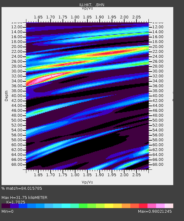
HKT Hockley, Texas - Earthquake Result Viewer

Earthquake location: Peru-Ecuador Border Region
Earthquake latitude/longitude: -2.8/-77.9
Earthquake time(UTC): 1995/10/03 (276) 12:45:00 GMT
Earthquake Depth: 33 km
Earthquake Magnitude: 6.0 MB, 6.1 MS, 5.9 UNKNOWN, 6.4 MW
Earthquake Catalog/Contributor: WHDF/NEIC
Network: IU Global Seismograph Network (GSN - IRIS/USGS)
Station: HKT Hockley, Texas
Lat/Lon: 29.96 N/95.84 W
Elevation: -413.0 m
Distance: 36.8 deg
Az: 333.519 deg
Baz: 149.122 deg
Ray Param: 0.07640354
Estimated Moho Depth: 31.75 km
Estimated Crust Vp/Vs: 1.70
Assumed Crust Vp: 5.581 km/s
Estimated Crust Vs: 3.278 km/s
Estimated Crust Poisson's Ratio: 0.24
Radial Match: 84.015785 %
Radial Bump: 388
Transverse Match: 57.121986 %
Transverse Bump: 400
SOD ConfigId: 6273
Insert Time: 2010-03-02 13:51:56.462 +0000
GWidth: 2.5
Max Bumps: 400
Tol: 0.001

Signal To Noise

ChannelStoNSTALTA
IU:HKT: :BHN:19951003T12:51:34.70199Z2.15523088.799877E-74.0830324E-7
IU:HKT: :BHE:19951003T12:51:34.70199Z1.35405434.4334902E-73.2742335E-7
IU:HKT: :BHZ:19951003T12:51:34.70199Z3.77986451.3391416E-63.5428295E-7
Arrivals
Ps4.2 SECOND
PpPs15 SECOND
PsPs/PpSs19 SECOND