You are here: Home > Network List > IM - International Miscellaneous Stations Stations List
> Station MK31 Makanchi Array Site 31, Kazakhstan > Earthquake Result Viewer
MK31 Makanchi Array Site 31, Kazakhstan - Earthquake Result Viewer
| Earthquake location: |
Solomon Islands |
| Earthquake latitude/longitude: |
-7.3/154.5 |
| Earthquake time(UTC): |
2015/05/07 (127) 07:10:22 GMT |
| Earthquake Depth: |
22 km |
| Earthquake Magnitude: |
7.2 MWP, 7.2 MI |
| Earthquake Catalog/Contributor: |
NEIC PDE/NEIC COMCAT |
|
| Network: |
IM International Miscellaneous Stations |
| Station: |
MK31 Makanchi Array Site 31, Kazakhstan |
| Lat/Lon: |
46.79 N/82.29 E |
| Elevation: |
618 m |
|
| Distance: |
83.3 deg |
| Az: |
318.79 deg |
| Baz: |
107.962 deg |
| Ray Param: |
0.04625496 |
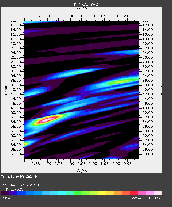
| Estimated Moho Depth: |
52.75 km |
| Estimated Crust Vp/Vs: |
1.70 |
| Assumed Crust Vp: |
6.688 km/s |
| Estimated Crust Vs: |
3.928 km/s |
| Estimated Crust Poisson's Ratio: |
0.24 |
|
| Radial Match: |
98.28279 % |
| Radial Bump: |
400 |
| Transverse Match: |
94.459595 % |
| Transverse Bump: |
400 |
| SOD ConfigId: |
7422571 |
| Insert Time: |
2019-04-18 17:22:44.375 +0000 |
| GWidth: |
2.5 |
| Max Bumps: |
400 |
| Tol: |
0.001 |
|

Signal To Noise
| Channel | StoN | STA | LTA |
| IM:MK31: :BHZ:20150507T07:22:15.799028Z | 106.42215 | 2.305537E-7 | 2.166407E-9 |
| IM:MK31: :BHN:20150507T07:22:15.799028Z | 11.13212 | 1.8462165E-8 | 1.658459E-9 |
| IM:MK31: :BHE:20150507T07:22:15.799028Z | 35.543495 | 6.6544075E-8 | 1.872187E-9 |
| Arrivals |
| Ps | 5.7 SECOND |
| PpPs | 21 SECOND |
| PsPs/PpSs | 26 SECOND |


