You are here: Home > Network List > TA - USArray Transportable Network (new EarthScope stations) Stations List
> Station R58A Rapidan, VA, USA > Earthquake Result Viewer
R58A Rapidan, VA, USA - Earthquake Result Viewer

| Earthquake location: |
Colombia-Ecuador Border Region |
| Earthquake latitude/longitude: |
0.6/-77.8 |
| Earthquake time(UTC): |
2014/10/20 (293) 19:33:21 GMT |
| Earthquake Depth: |
10 km |
| Earthquake Magnitude: |
6.0 MB, 5.6 MWB |
| Earthquake Catalog/Contributor: |
NEIC PDE/NEIC COMCAT |
|
| Network: |
TA USArray Transportable Network (new EarthScope stations) |
| Station: |
R58A Rapidan, VA, USA |
| Lat/Lon: |
38.30 N/78.00 W |
| Elevation: |
184 m |
|
| Distance: |
37.5 deg |
| Az: |
359.799 deg |
| Baz: |
179.744 deg |
| Ray Param: |
0.076088436 |
| Estimated Moho Depth: |
26.25 km |
| Estimated Crust Vp/Vs: |
1.77 |
| Assumed Crust Vp: |
6.159 km/s |
| Estimated Crust Vs: |
3.479 km/s |
| Estimated Crust Poisson's Ratio: |
0.27 |
|
| Radial Match: |
86.93615 % |
| Radial Bump: |
383 |
| Transverse Match: |
66.65054 % |
| Transverse Bump: |
396 |
| SOD ConfigId: |
803114 |
| Insert Time: |
2014-11-03 20:06:04.790 +0000 |
| GWidth: |
2.5 |
| Max Bumps: |
400 |
| Tol: |
0.001 |
|
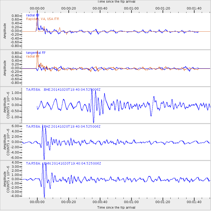
Signal To Noise
| Channel | StoN | STA | LTA |
| TA:R58A: :BHZ:20141020T19:40:04.525006Z | 13.1160145 | 2.7965598E-6 | 2.1321719E-7 |
| TA:R58A: :BHN:20141020T19:40:04.525006Z | 5.9081607 | 1.7710125E-6 | 2.99757E-7 |
| TA:R58A: :BHE:20141020T19:40:04.525006Z | 1.5669302 | 3.86455E-7 | 2.4663194E-7 |
| Arrivals |
| Ps | 3.5 SECOND |
| PpPs | 11 SECOND |
| PsPs/PpSs | 15 SECOND |


