You are here: Home > Network List > TA - USArray Transportable Network (new EarthScope stations) Stations List
> Station R59A King George, VA, USA > Earthquake Result Viewer
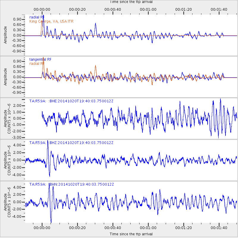
R59A King George, VA, USA - Earthquake Result Viewer
*The percent match for this event was below the threshold and hence no stack was calculated.
| Earthquake location: |
Colombia-Ecuador Border Region |
| Earthquake latitude/longitude: |
0.6/-77.8 |
| Earthquake time(UTC): |
2014/10/20 (293) 19:33:21 GMT |
| Earthquake Depth: |
10 km |
| Earthquake Magnitude: |
6.0 MB, 5.6 MWB |
| Earthquake Catalog/Contributor: |
NEIC PDE/NEIC COMCAT |
|
| Network: |
TA USArray Transportable Network (new EarthScope stations) |
| Station: |
R59A King George, VA, USA |
| Lat/Lon: |
38.20 N/77.12 W |
| Elevation: |
35 m |
|
| Distance: |
37.4 deg |
| Az: |
0.948 deg |
| Baz: |
181.203 deg |
| Ray Param: |
$rayparam |
*The percent match for this event was below the threshold and hence was not used in the summary stack. |
|
| Radial Match: |
72.62331 % |
| Radial Bump: |
400 |
| Transverse Match: |
60.19778 % |
| Transverse Bump: |
400 |
| SOD ConfigId: |
803114 |
| Insert Time: |
2014-11-03 20:06:09.600 +0000 |
| GWidth: |
2.5 |
| Max Bumps: |
400 |
| Tol: |
0.001 |
|
Signal To Noise
| Channel | StoN | STA | LTA |
| TA:R59A: :BHZ:20141020T19:40:03.750012Z | 5.2236023 | 2.024734E-6 | 3.8761257E-7 |
| TA:R59A: :BHN:20141020T19:40:03.750012Z | 2.7391846 | 1.8101285E-6 | 6.608275E-7 |
| TA:R59A: :BHE:20141020T19:40:03.750012Z | 1.2942637 | 7.64953E-7 | 5.910333E-7 |
| Arrivals |
| Ps | |
| PpPs | |
| PsPs/PpSs | |


