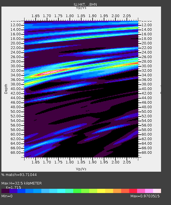
HKT Hockley, Texas - Earthquake Result Viewer
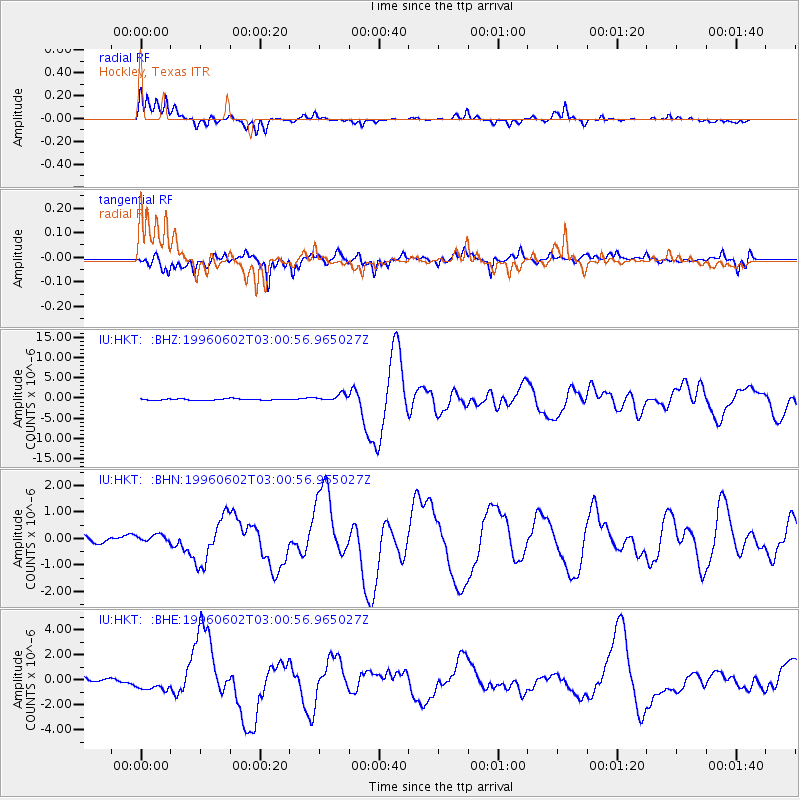
Earthquake location: Northern Mid-Atlantic Ridge
Earthquake latitude/longitude: 10.8/-42.3
Earthquake time(UTC): 1996/06/02 (154) 02:52:09 GMT
Earthquake Depth: 10 km
Earthquake Magnitude: 6.1 MB, 6.9 MS, 7.0 UNKNOWN, 6.8 MW
Earthquake Catalog/Contributor: WHDF/NEIC
Network: IU Global Seismograph Network (GSN - IRIS/USGS)
Station: HKT Hockley, Texas
Lat/Lon: 29.96 N/95.84 W
Elevation: -413.0 m
Distance: 53.2 deg
Az: 299.328 deg
Baz: 99.218 deg
Ray Param: 0.06624139
Estimated Moho Depth: 32.5 km
Estimated Crust Vp/Vs: 1.72
Assumed Crust Vp: 5.581 km/s
Estimated Crust Vs: 3.255 km/s
Estimated Crust Poisson's Ratio: 0.24
Radial Match: 93.71044 %
Radial Bump: 338
Transverse Match: 85.74617 %
Transverse Bump: 400
SOD ConfigId: 6273
Insert Time: 2010-03-02 13:52:16.605 +0000
GWidth: 2.5
Max Bumps: 400
Tol: 0.001

Signal To Noise

ChannelStoNSTALTA
IU:HKT: :BHN:19960602T03:00:56.965027Z1.00972181.4225888E-71.4088918E-7
IU:HKT: :BHE:19960602T03:00:56.965027Z2.14780765.867299E-72.731762E-7
IU:HKT: :BHZ:19960602T03:00:56.965027Z5.05330328.986886E-71.7784181E-7
Arrivals
Ps4.3 SECOND
PpPs15 SECOND
PsPs/PpSs20 SECOND