You are here: Home > Network List > TA - USArray Transportable Network (new EarthScope stations) Stations List
> Station V58A Windy Hill, Pittsboro, NC, USA > Earthquake Result Viewer
V58A Windy Hill, Pittsboro, NC, USA - Earthquake Result Viewer
| Earthquake location: |
Colombia-Ecuador Border Region |
| Earthquake latitude/longitude: |
0.6/-77.8 |
| Earthquake time(UTC): |
2014/10/20 (293) 19:33:21 GMT |
| Earthquake Depth: |
10 km |
| Earthquake Magnitude: |
6.0 MB, 5.6 MWB |
| Earthquake Catalog/Contributor: |
NEIC PDE/NEIC COMCAT |
|
| Network: |
TA USArray Transportable Network (new EarthScope stations) |
| Station: |
V58A Windy Hill, Pittsboro, NC, USA |
| Lat/Lon: |
35.79 N/79.11 W |
| Elevation: |
127 m |
|
| Distance: |
35.0 deg |
| Az: |
358.205 deg |
| Baz: |
177.792 deg |
| Ray Param: |
0.07742814 |
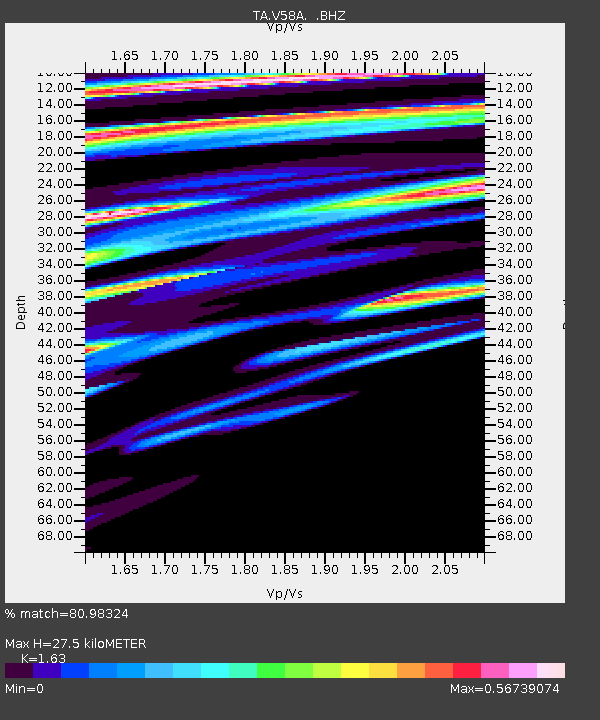
| Estimated Moho Depth: |
27.5 km |
| Estimated Crust Vp/Vs: |
1.63 |
| Assumed Crust Vp: |
6.565 km/s |
| Estimated Crust Vs: |
4.027 km/s |
| Estimated Crust Poisson's Ratio: |
0.20 |
|
| Radial Match: |
80.98324 % |
| Radial Bump: |
400 |
| Transverse Match: |
51.552048 % |
| Transverse Bump: |
400 |
| SOD ConfigId: |
803114 |
| Insert Time: |
2014-11-03 20:07:47.851 +0000 |
| GWidth: |
2.5 |
| Max Bumps: |
400 |
| Tol: |
0.001 |
|
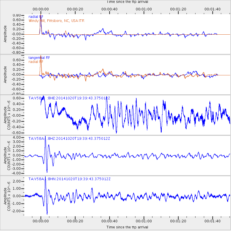
Signal To Noise
| Channel | StoN | STA | LTA |
| TA:V58A: :BHZ:20141020T19:39:43.375012Z | 15.958553 | 1.8518467E-6 | 1.16041015E-7 |
| TA:V58A: :BHN:20141020T19:39:43.375012Z | 11.982188 | 1.1016325E-6 | 9.193918E-8 |
| TA:V58A: :BHE:20141020T19:39:43.375012Z | 0.6202905 | 1.6352384E-7 | 2.636246E-7 |
| Arrivals |
| Ps | 2.9 SECOND |
| PpPs | 10 SECOND |
| PsPs/PpSs | 13 SECOND |


