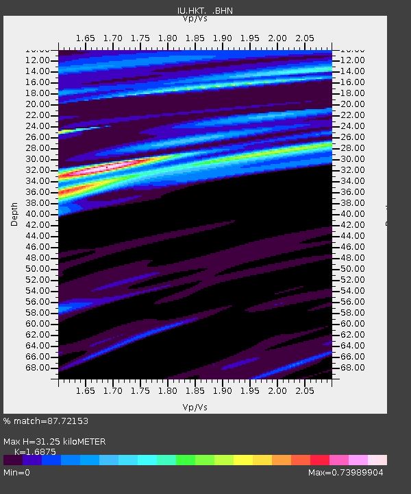
HKT Hockley, Texas - Earthquake Result Viewer
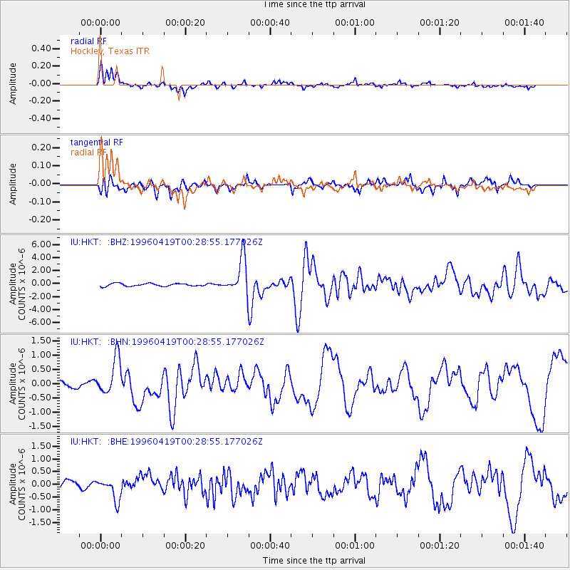
Earthquake location: Near Coast Of Northern Chile
Earthquake latitude/longitude: -23.9/-70.1
Earthquake time(UTC): 1996/04/19 (110) 00:19:31 GMT
Earthquake Depth: 50 km
Earthquake Magnitude: 6.0 MB, 6.1 MS, 6.6 UNKNOWN, 6.5 ME
Earthquake Catalog/Contributor: WHDF/NEIC
Network: IU Global Seismograph Network (GSN - IRIS/USGS)
Station: HKT Hockley, Texas
Lat/Lon: 29.96 N/95.84 W
Elevation: -413.0 m
Distance: 59.0 deg
Az: 333.919 deg
Baz: 152.385 deg
Ray Param: 0.062345054
Estimated Moho Depth: 31.25 km
Estimated Crust Vp/Vs: 1.69
Assumed Crust Vp: 5.581 km/s
Estimated Crust Vs: 3.308 km/s
Estimated Crust Poisson's Ratio: 0.23
Radial Match: 87.72153 %
Radial Bump: 383
Transverse Match: 82.706116 %
Transverse Bump: 400
SOD ConfigId: 6273
Insert Time: 2010-03-02 13:52:28.078 +0000
GWidth: 2.5
Max Bumps: 400
Tol: 0.001

Signal To Noise

ChannelStoNSTALTA
IU:HKT: :BHN:19960419T00:28:55.177026Z6.94379856.6596715E-79.590819E-8
IU:HKT: :BHE:19960419T00:28:55.177026Z2.81232864.5294726E-71.6105773E-7
IU:HKT: :BHZ:19960419T00:28:55.177026Z13.7714992.8756401E-62.0881097E-7
Arrivals
Ps4.0 SECOND
PpPs14 SECOND
PsPs/PpSs18 SECOND