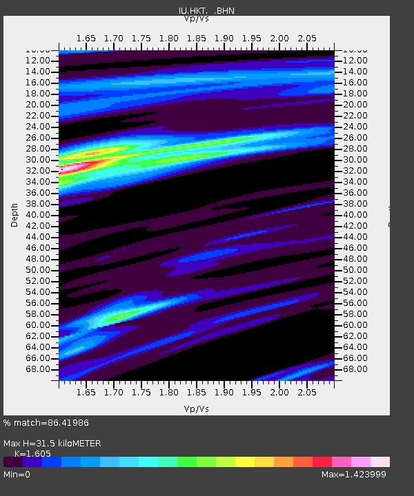
HKT Hockley, Texas - Earthquake Result Viewer
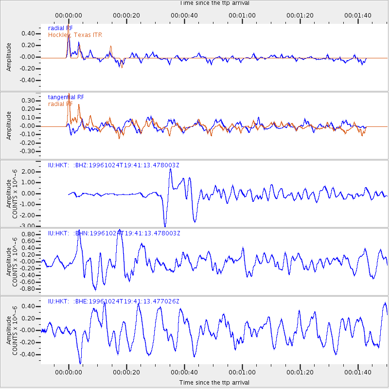
Earthquake location: Near N. Coast Of Eastern Siberia
Earthquake latitude/longitude: 67.0/-173.2
Earthquake time(UTC): 1996/10/24 (298) 19:31:53 GMT
Earthquake Depth: 20 km
Earthquake Magnitude: 6.0 MB, 5.9 MS, 6.1 UNKNOWN, 5.8 ME
Earthquake Catalog/Contributor: WHDF/NEIC
Network: IU Global Seismograph Network (GSN - IRIS/USGS)
Station: HKT Hockley, Texas
Lat/Lon: 29.96 N/95.84 W
Elevation: -413.0 m
Distance: 57.9 deg
Az: 88.567 deg
Baz: 333.068 deg
Ray Param: 0.06317081
Estimated Moho Depth: 31.5 km
Estimated Crust Vp/Vs: 1.61
Assumed Crust Vp: 5.581 km/s
Estimated Crust Vs: 3.478 km/s
Estimated Crust Poisson's Ratio: 0.18
Radial Match: 86.41986 %
Radial Bump: 400
Transverse Match: 58.887684 %
Transverse Bump: 400
SOD ConfigId: 6273
Insert Time: 2010-03-02 13:52:32.292 +0000
GWidth: 2.5
Max Bumps: 400
Tol: 0.001

Signal To Noise

ChannelStoNSTALTA
IU:HKT: :BHN:19961024T19:41:13.478003Z2.4233244.0256222E-71.6611983E-7
IU:HKT: :BHE:19961024T19:41:13.477026Z2.10069822.3666303E-71.12659215E-7
IU:HKT: :BHZ:19961024T19:41:13.478003Z15.102491.2176026E-68.062264E-8
Arrivals
Ps3.6 SECOND
PpPs14 SECOND
PsPs/PpSs18 SECOND