You are here: Home > Network List > NN - Western Great Basin/Eastern Sierra Nevada Stations List
> Station SHP Sheep Range, Nevada w84gm > Earthquake Result Viewer
SHP Sheep Range, Nevada w84gm - Earthquake Result Viewer
| Earthquake location: |
Solomon Islands |
| Earthquake latitude/longitude: |
-7.3/154.5 |
| Earthquake time(UTC): |
2015/05/07 (127) 07:10:22 GMT |
| Earthquake Depth: |
22 km |
| Earthquake Magnitude: |
7.2 MWP, 7.2 MI |
| Earthquake Catalog/Contributor: |
NEIC PDE/NEIC COMCAT |
|
| Network: |
NN Western Great Basin/Eastern Sierra Nevada |
| Station: |
SHP Sheep Range, Nevada w84gm |
| Lat/Lon: |
36.50 N/115.16 W |
| Elevation: |
1632 m |
|
| Distance: |
94.5 deg |
| Az: |
53.922 deg |
| Baz: |
264.346 deg |
| Ray Param: |
0.04101742 |
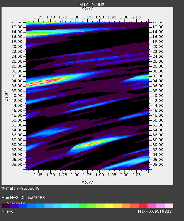
| Estimated Moho Depth: |
34.5 km |
| Estimated Crust Vp/Vs: |
1.65 |
| Assumed Crust Vp: |
6.276 km/s |
| Estimated Crust Vs: |
3.798 km/s |
| Estimated Crust Poisson's Ratio: |
0.21 |
|
| Radial Match: |
95.68049 % |
| Radial Bump: |
350 |
| Transverse Match: |
83.84553 % |
| Transverse Bump: |
400 |
| SOD ConfigId: |
7422571 |
| Insert Time: |
2019-04-18 17:23:47.130 +0000 |
| GWidth: |
2.5 |
| Max Bumps: |
400 |
| Tol: |
0.001 |
|

Signal To Noise
| Channel | StoN | STA | LTA |
| NN:SHP: :HHZ:20150507T07:23:08.969988Z | 3.9791448 | 6.014066E-7 | 1.5113967E-7 |
| NN:SHP: :HHN:20150507T07:23:08.969988Z | 0.28072262 | 4.0454903E-8 | 1.4410988E-7 |
| NN:SHP: :HHE:20150507T07:23:08.969988Z | 1.2821255 | 1.7454448E-7 | 1.3613682E-7 |
| Arrivals |
| Ps | 3.7 SECOND |
| PpPs | 14 SECOND |
| PsPs/PpSs | 18 SECOND |


