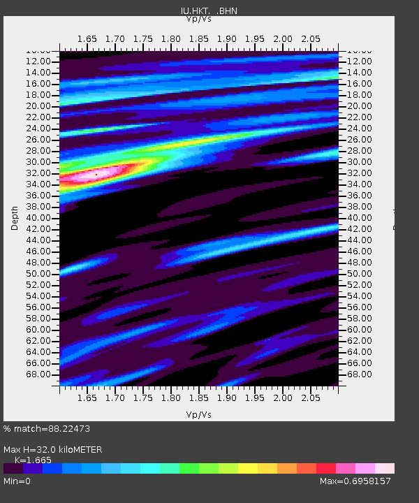
HKT Hockley, Texas - Earthquake Result Viewer
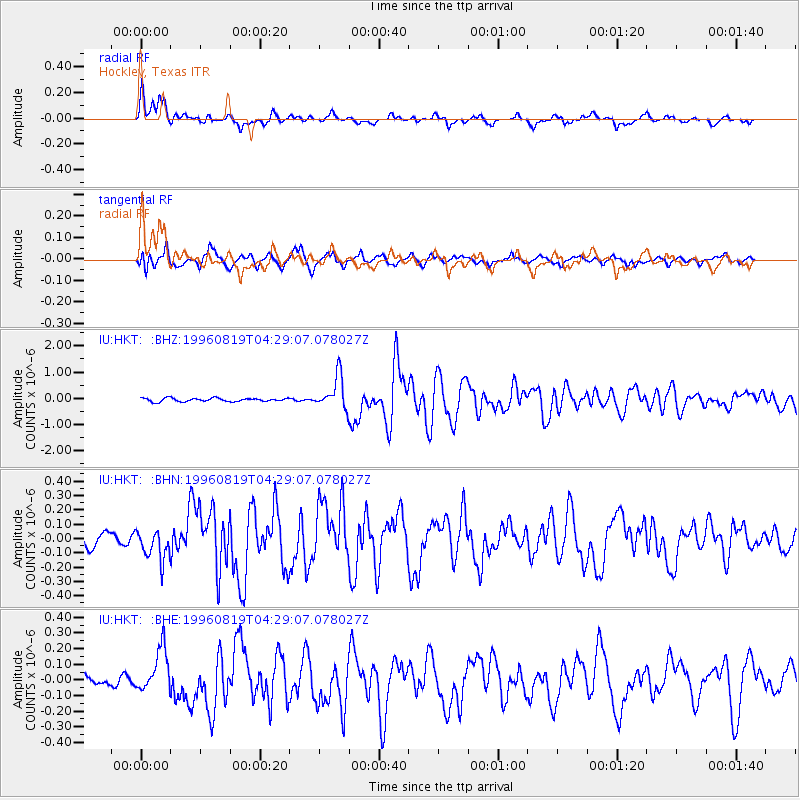
Earthquake location: Andreanof Islands, Aleutian Is.
Earthquake latitude/longitude: 51.5/-178.4
Earthquake time(UTC): 1996/08/19 (232) 04:19:16 GMT
Earthquake Depth: 33 km
Earthquake Magnitude: 5.7 MB, 5.6 MS, 6.0 UNKNOWN, 5.7 ML
Earthquake Catalog/Contributor: WHDF/NEIC
Network: IU Global Seismograph Network (GSN - IRIS/USGS)
Station: HKT Hockley, Texas
Lat/Lon: 29.96 N/95.84 W
Elevation: -413.0 m
Distance: 62.7 deg
Az: 75.476 deg
Baz: 315.732 deg
Ray Param: 0.05998254
Estimated Moho Depth: 32.0 km
Estimated Crust Vp/Vs: 1.66
Assumed Crust Vp: 5.581 km/s
Estimated Crust Vs: 3.352 km/s
Estimated Crust Poisson's Ratio: 0.22
Radial Match: 88.22473 %
Radial Bump: 400
Transverse Match: 77.28076 %
Transverse Bump: 400
SOD ConfigId: 6273
Insert Time: 2010-03-02 13:52:34.674 +0000
GWidth: 2.5
Max Bumps: 400
Tol: 0.001

Signal To Noise

ChannelStoNSTALTA
IU:HKT: :BHN:19960819T04:29:07.078027Z2.3219211.0508401E-74.5257355E-8
IU:HKT: :BHE:19960819T04:29:07.078027Z2.86262511.3903691E-74.8569724E-8
IU:HKT: :BHZ:19960819T04:29:07.078027Z9.495826.2124514E-76.5423E-8
Arrivals
Ps3.9 SECOND
PpPs15 SECOND
PsPs/PpSs19 SECOND