You are here: Home > Network List > TA - USArray Transportable Network (new EarthScope stations) Stations List
> Station X55A Gracelyn & Ava, Whitmire, SC, USA > Earthquake Result Viewer
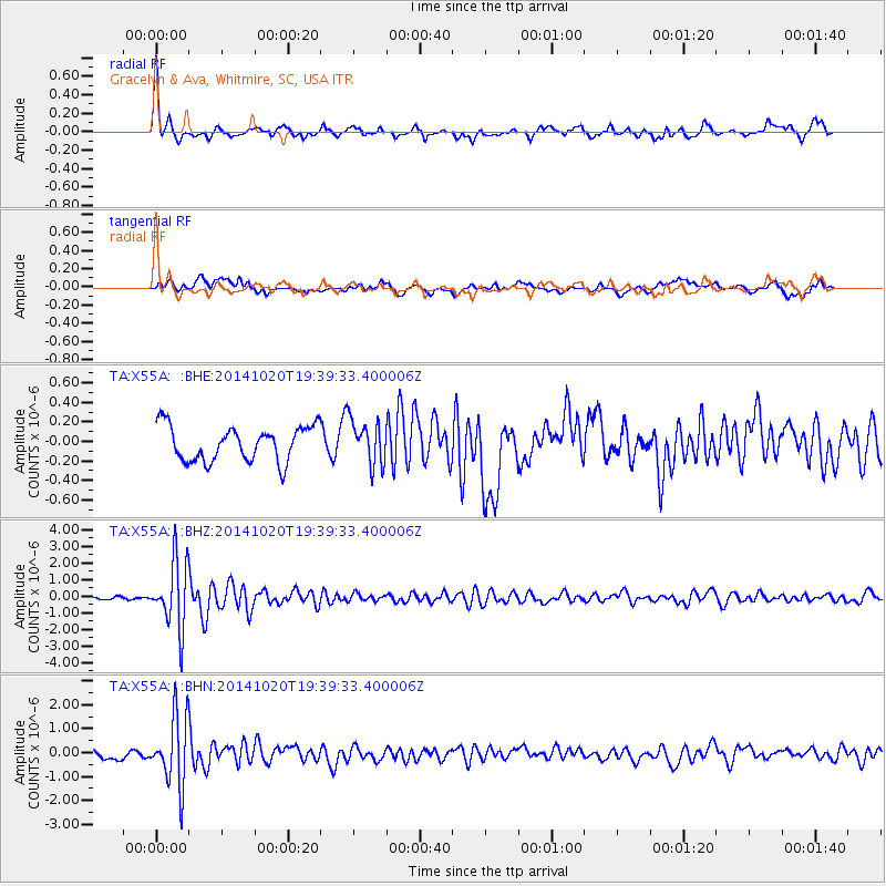
X55A Gracelyn & Ava, Whitmire, SC, USA - Earthquake Result Viewer

| Earthquake location: |
Colombia-Ecuador Border Region |
| Earthquake latitude/longitude: |
0.6/-77.8 |
| Earthquake time(UTC): |
2014/10/20 (293) 19:33:21 GMT |
| Earthquake Depth: |
10 km |
| Earthquake Magnitude: |
6.0 MB, 5.6 MWB |
| Earthquake Catalog/Contributor: |
NEIC PDE/NEIC COMCAT |
|
| Network: |
TA USArray Transportable Network (new EarthScope stations) |
| Station: |
X55A Gracelyn & Ava, Whitmire, SC, USA |
| Lat/Lon: |
34.47 N/81.63 W |
| Elevation: |
153 m |
|
| Distance: |
33.9 deg |
| Az: |
354.385 deg |
| Baz: |
173.199 deg |
| Ray Param: |
0.07799969 |
| Estimated Moho Depth: |
59.5 km |
| Estimated Crust Vp/Vs: |
1.93 |
| Assumed Crust Vp: |
6.419 km/s |
| Estimated Crust Vs: |
3.317 km/s |
| Estimated Crust Poisson's Ratio: |
0.32 |
|
| Radial Match: |
80.554245 % |
| Radial Bump: |
400 |
| Transverse Match: |
48.767807 % |
| Transverse Bump: |
400 |
| SOD ConfigId: |
803114 |
| Insert Time: |
2014-11-03 20:08:32.101 +0000 |
| GWidth: |
2.5 |
| Max Bumps: |
400 |
| Tol: |
0.001 |
|
Signal To Noise
| Channel | StoN | STA | LTA |
| TA:X55A: :BHZ:20141020T19:39:33.400006Z | 14.082112 | 2.0235568E-6 | 1.4369695E-7 |
| TA:X55A: :BHN:20141020T19:39:33.400006Z | 9.819935 | 1.456663E-6 | 1.4833734E-7 |
| TA:X55A: :BHE:20141020T19:39:33.400006Z | 1.271007 | 2.2647488E-7 | 1.781854E-7 |
| Arrivals |
| Ps | 9.3 SECOND |
| PpPs | 25 SECOND |
| PsPs/PpSs | 35 SECOND |


