You are here: Home > Network List > TA - USArray Transportable Network (new EarthScope stations) Stations List
> Station Y57A Sumter, SC, USA > Earthquake Result Viewer
Y57A Sumter, SC, USA - Earthquake Result Viewer
| Earthquake location: |
Colombia-Ecuador Border Region |
| Earthquake latitude/longitude: |
0.6/-77.8 |
| Earthquake time(UTC): |
2014/10/20 (293) 19:33:21 GMT |
| Earthquake Depth: |
10 km |
| Earthquake Magnitude: |
6.0 MB, 5.6 MWB |
| Earthquake Catalog/Contributor: |
NEIC PDE/NEIC COMCAT |
|
| Network: |
TA USArray Transportable Network (new EarthScope stations) |
| Station: |
Y57A Sumter, SC, USA |
| Lat/Lon: |
34.02 N/80.39 W |
| Elevation: |
56 m |
|
| Distance: |
33.3 deg |
| Az: |
356.153 deg |
| Baz: |
175.368 deg |
| Ray Param: |
0.07825398 |
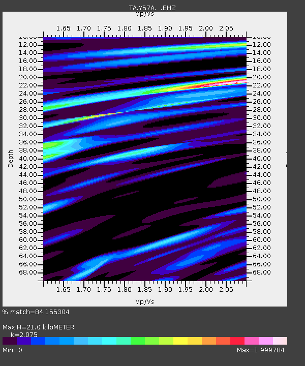
| Estimated Moho Depth: |
21.0 km |
| Estimated Crust Vp/Vs: |
2.08 |
| Assumed Crust Vp: |
6.419 km/s |
| Estimated Crust Vs: |
3.094 km/s |
| Estimated Crust Poisson's Ratio: |
0.35 |
|
| Radial Match: |
84.155304 % |
| Radial Bump: |
400 |
| Transverse Match: |
71.18397 % |
| Transverse Bump: |
400 |
| SOD ConfigId: |
803114 |
| Insert Time: |
2014-11-03 20:08:49.507 +0000 |
| GWidth: |
2.5 |
| Max Bumps: |
400 |
| Tol: |
0.001 |
|
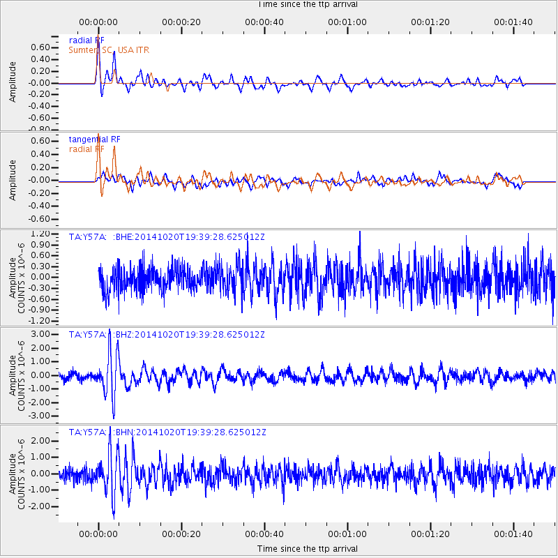
Signal To Noise
| Channel | StoN | STA | LTA |
| TA:Y57A: :BHZ:20141020T19:39:28.625012Z | 6.8505764 | 1.6272959E-6 | 2.3754144E-7 |
| TA:Y57A: :BHN:20141020T19:39:28.625012Z | 3.7653167 | 1.3043638E-6 | 3.4641542E-7 |
| TA:Y57A: :BHE:20141020T19:39:28.625012Z | 1.2495936 | 3.759088E-7 | 3.0082484E-7 |
| Arrivals |
| Ps | 3.8 SECOND |
| PpPs | 9.4 SECOND |
| PsPs/PpSs | 13 SECOND |


