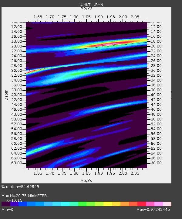
HKT Hockley, Texas - Earthquake Result Viewer
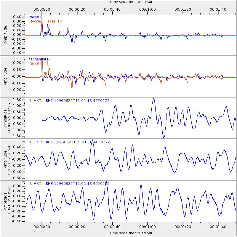
Earthquake location: Off East Coast Of Kamchatka
Earthquake latitude/longitude: 51.4/159.2
Earthquake time(UTC): 1996/06/22 (174) 14:50:07 GMT
Earthquake Depth: 33 km
Earthquake Magnitude: 5.6 MB, 6.0 MS, 6.2 UNKNOWN, 6.2 MW
Earthquake Catalog/Contributor: WHDF/NEIC
Network: IU Global Seismograph Network (GSN - IRIS/USGS)
Station: HKT Hockley, Texas
Lat/Lon: 29.96 N/95.84 W
Elevation: -413.0 m
Distance: 75.7 deg
Az: 59.931 deg
Baz: 321.337 deg
Ray Param: 0.051457364
Estimated Moho Depth: 29.75 km
Estimated Crust Vp/Vs: 1.62
Assumed Crust Vp: 5.581 km/s
Estimated Crust Vs: 3.456 km/s
Estimated Crust Poisson's Ratio: 0.19
Radial Match: 84.62949 %
Radial Bump: 325
Transverse Match: 66.93211 %
Transverse Bump: 356
SOD ConfigId: 6273
Insert Time: 2010-03-02 13:52:41.841 +0000
GWidth: 2.5
Max Bumps: 400
Tol: 0.001

Signal To Noise

ChannelStoNSTALTA
IU:HKT: :BHN:19960622T15:01:18.465027Z1.38442621.3518265E-79.764525E-8
IU:HKT: :BHE:19960622T15:01:18.465027Z1.95615041.5749794E-78.0514226E-8
IU:HKT: :BHZ:19960622T15:01:18.465027Z3.16505173.5145987E-71.1104396E-7
Arrivals
Ps3.4 SECOND
PpPs14 SECOND
PsPs/PpSs17 SECOND