You are here: Home > Network List > US - United States National Seismic Network Stations List
> Station CBKS Cedar Bluff, Kansas, USA > Earthquake Result Viewer
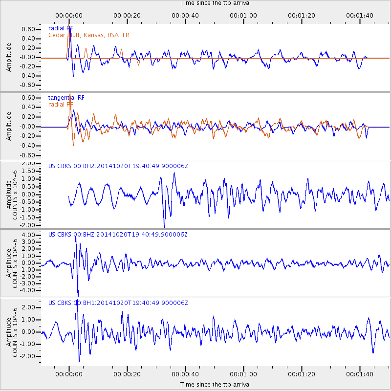
CBKS Cedar Bluff, Kansas, USA - Earthquake Result Viewer
*The percent match for this event was below the threshold and hence no stack was calculated.
| Earthquake location: |
Colombia-Ecuador Border Region |
| Earthquake latitude/longitude: |
0.6/-77.8 |
| Earthquake time(UTC): |
2014/10/20 (293) 19:33:21 GMT |
| Earthquake Depth: |
10 km |
| Earthquake Magnitude: |
6.0 MB, 5.6 MWB |
| Earthquake Catalog/Contributor: |
NEIC PDE/NEIC COMCAT |
|
| Network: |
US United States National Seismic Network |
| Station: |
CBKS Cedar Bluff, Kansas, USA |
| Lat/Lon: |
38.81 N/99.74 W |
| Elevation: |
677 m |
|
| Distance: |
43.0 deg |
| Az: |
334.722 deg |
| Baz: |
146.869 deg |
| Ray Param: |
$rayparam |
*The percent match for this event was below the threshold and hence was not used in the summary stack. |
|
| Radial Match: |
73.20568 % |
| Radial Bump: |
400 |
| Transverse Match: |
66.340836 % |
| Transverse Bump: |
400 |
| SOD ConfigId: |
803114 |
| Insert Time: |
2014-11-03 20:09:53.574 +0000 |
| GWidth: |
2.5 |
| Max Bumps: |
400 |
| Tol: |
0.001 |
|
Signal To Noise
| Channel | StoN | STA | LTA |
| US:CBKS:00:BHZ:20141020T19:40:49.900006Z | 7.652101 | 1.9276238E-6 | 2.519078E-7 |
| US:CBKS:00:BH1:20141020T19:40:49.900006Z | 3.758139 | 1.1849585E-6 | 3.1530462E-7 |
| US:CBKS:00:BH2:20141020T19:40:49.900006Z | 1.9483153 | 8.233177E-7 | 4.225793E-7 |
| Arrivals |
| Ps | |
| PpPs | |
| PsPs/PpSs | |


