You are here: Home > Network List > TA - USArray Transportable Network (new EarthScope stations) Stations List
> Station C36M Paulatuk, NT, CAN > Earthquake Result Viewer
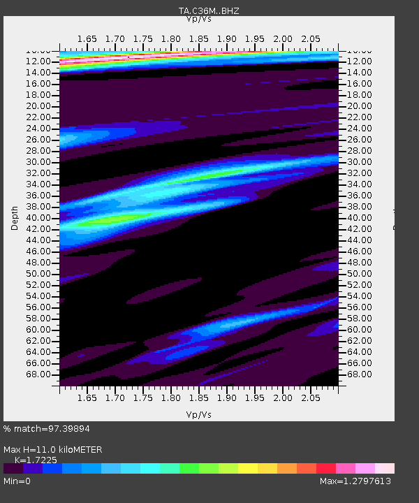
C36M Paulatuk, NT, CAN - Earthquake Result Viewer
| Earthquake location: |
Solomon Islands |
| Earthquake latitude/longitude: |
-7.3/154.5 |
| Earthquake time(UTC): |
2015/05/07 (127) 07:10:22 GMT |
| Earthquake Depth: |
22 km |
| Earthquake Magnitude: |
7.2 MWP, 7.2 MI |
| Earthquake Catalog/Contributor: |
NEIC PDE/NEIC COMCAT |
|
| Network: |
TA USArray Transportable Network (new EarthScope stations) |
| Station: |
C36M Paulatuk, NT, CAN |
| Lat/Lon: |
69.35 N/124.07 W |
| Elevation: |
10 m |
|
| Distance: |
93.7 deg |
| Az: |
20.581 deg |
| Baz: |
259.409 deg |
| Ray Param: |
0.041198276 |
| Estimated Moho Depth: |
11.0 km |
| Estimated Crust Vp/Vs: |
1.72 |
| Assumed Crust Vp: |
6.459 km/s |
| Estimated Crust Vs: |
3.75 km/s |
| Estimated Crust Poisson's Ratio: |
0.25 |
|
| Radial Match: |
97.39894 % |
| Radial Bump: |
278 |
| Transverse Match: |
98.30801 % |
| Transverse Bump: |
293 |
| SOD ConfigId: |
7422571 |
| Insert Time: |
2019-04-18 17:24:30.335 +0000 |
| GWidth: |
2.5 |
| Max Bumps: |
400 |
| Tol: |
0.001 |
|

Signal To Noise
| Channel | StoN | STA | LTA |
| TA:C36M: :BHZ:20150507T07:23:05.424028Z | 5.030513 | 1.0227275E-6 | 2.0330481E-7 |
| TA:C36M: :BHN:20150507T07:23:05.424028Z | 1.3354789 | 1.8093786E-7 | 1.3548538E-7 |
| TA:C36M: :BHE:20150507T07:23:05.424028Z | 2.76599 | 2.3328323E-7 | 8.433987E-8 |
| Arrivals |
| Ps | 1.3 SECOND |
| PpPs | 4.5 SECOND |
| PsPs/PpSs | 5.8 SECOND |


