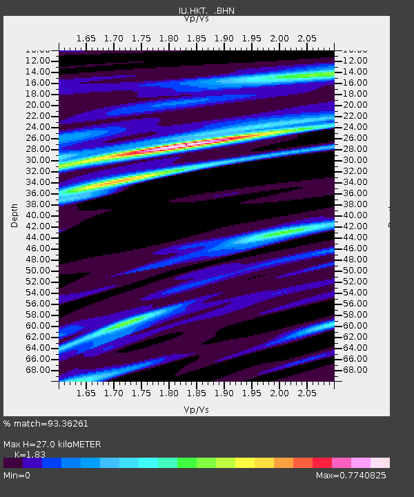
HKT Hockley, Texas - Earthquake Result Viewer
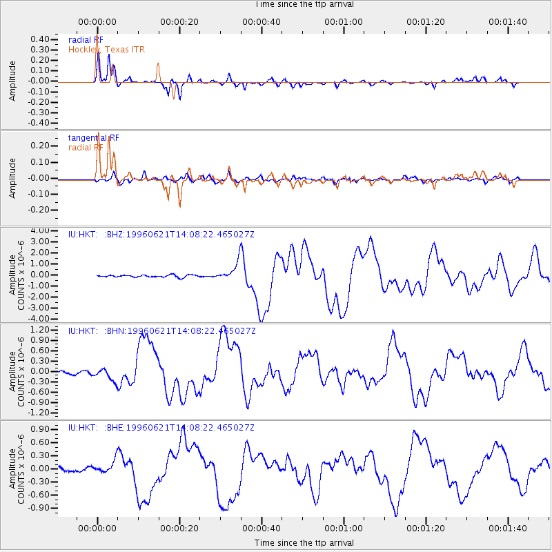
Earthquake location: Off East Coast Of Kamchatka
Earthquake latitude/longitude: 51.6/159.1
Earthquake time(UTC): 1996/06/21 (173) 13:57:10 GMT
Earthquake Depth: 20 km
Earthquake Magnitude: 6.0 MB, 6.6 MS, 7.0 UNKNOWN, 6.5 MS
Earthquake Catalog/Contributor: WHDF/NEIC
Network: IU Global Seismograph Network (GSN - IRIS/USGS)
Station: HKT Hockley, Texas
Lat/Lon: 29.96 N/95.84 W
Elevation: -413.0 m
Distance: 75.7 deg
Az: 59.884 deg
Baz: 321.527 deg
Ray Param: 0.051499464
Estimated Moho Depth: 27.0 km
Estimated Crust Vp/Vs: 1.83
Assumed Crust Vp: 5.581 km/s
Estimated Crust Vs: 3.05 km/s
Estimated Crust Poisson's Ratio: 0.29
Radial Match: 93.36261 %
Radial Bump: 360
Transverse Match: 75.359085 %
Transverse Bump: 400
SOD ConfigId: 6273
Insert Time: 2010-03-02 13:52:53.360 +0000
GWidth: 2.5
Max Bumps: 400
Tol: 0.001

Signal To Noise

ChannelStoNSTALTA
IU:HKT: :BHN:19960621T14:08:22.465027Z3.50049951.8419684E-75.262016E-8
IU:HKT: :BHE:19960621T14:08:22.465027Z2.73133061.4968465E-75.480283E-8
IU:HKT: :BHZ:19960621T14:08:22.465027Z8.0489678.1642435E-71.0143219E-7
Arrivals
Ps4.1 SECOND
PpPs13 SECOND
PsPs/PpSs17 SECOND