You are here: Home > Network List > IU - Global Seismograph Network (GSN - IRIS/USGS) Stations List
> Station HKT Hockley, Texas > Earthquake Result Viewer
HKT Hockley, Texas - Earthquake Result Viewer
| Earthquake location: |
Fiji Islands Region |
| Earthquake latitude/longitude: |
-20.7/-178.3 |
| Earthquake time(UTC): |
1996/08/05 (218) 22:38:22 GMT |
| Earthquake Depth: |
550 km |
| Earthquake Magnitude: |
6.4 MB, 7.4 UNKNOWN, 7.3 MW |
| Earthquake Catalog/Contributor: |
WHDF/NEIC |
|
| Network: |
IU Global Seismograph Network (GSN - IRIS/USGS) |
| Station: |
HKT Hockley, Texas |
| Lat/Lon: |
29.96 N/95.84 W |
| Elevation: |
-413.0 m |
|
| Distance: |
93.9 deg |
| Az: |
59.579 deg |
| Baz: |
248.493 deg |
| Ray Param: |
0.04065314 |
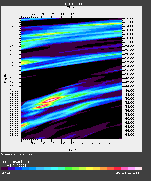
| Estimated Moho Depth: |
50.5 km |
| Estimated Crust Vp/Vs: |
1.75 |
| Assumed Crust Vp: |
5.581 km/s |
| Estimated Crust Vs: |
3.194 km/s |
| Estimated Crust Poisson's Ratio: |
0.26 |
|
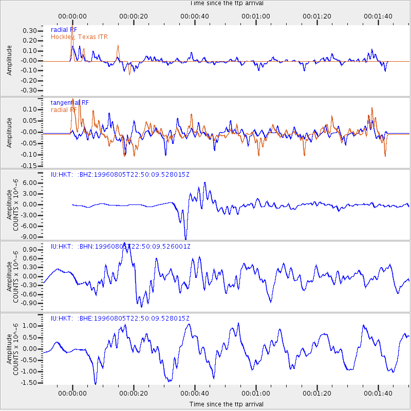
| Radial Match: |
89.73179 % |
| Radial Bump: |
387 |
| Transverse Match: |
90.77645 % |
| Transverse Bump: |
367 |
| SOD ConfigId: |
6273 |
| Insert Time: |
2010-03-02 13:52:57.715 +0000 |
| GWidth: |
2.5 |
| Max Bumps: |
400 |
| Tol: |
0.001 |
|
Signal To Noise
| Channel | StoN | STA | LTA |
| IU:HKT: :BHN:19960805T22:50:09.526001Z | 1.3195658 | 1.6967894E-7 | 1.2858695E-7 |
| IU:HKT: :BHE:19960805T22:50:09.528015Z | 0.35570142 | 6.750035E-8 | 1.8976688E-7 |
| IU:HKT: :BHZ:19960805T22:50:09.528015Z | 3.758521 | 9.191376E-7 | 2.445477E-7 |
| Arrivals |
| Ps | 6.9 SECOND |
| PpPs | 24 SECOND |
| PsPs/PpSs | 31 SECOND |


