You are here: Home > Network List > IU - Global Seismograph Network (GSN - IRIS/USGS) Stations List
> Station HKT Hockley, Texas > Earthquake Result Viewer
HKT Hockley, Texas - Earthquake Result Viewer
| Earthquake location: |
Windward Islands |
| Earthquake latitude/longitude: |
11.4/-60.9 |
| Earthquake time(UTC): |
1997/04/02 (092) 06:14:31 GMT |
| Earthquake Depth: |
45 km |
| Earthquake Magnitude: |
5.8 MB, 5.5 MS, 6.2 UNKNOWN, 5.6 MD |
| Earthquake Catalog/Contributor: |
WHDF/NEIC |
|
| Network: |
IU Global Seismograph Network (GSN - IRIS/USGS) |
| Station: |
HKT Hockley, Texas |
| Lat/Lon: |
29.96 N/95.84 W |
| Elevation: |
-413.0 m |
|
| Distance: |
37.3 deg |
| Az: |
304.973 deg |
| Baz: |
112.208 deg |
| Ray Param: |
0.07611046 |
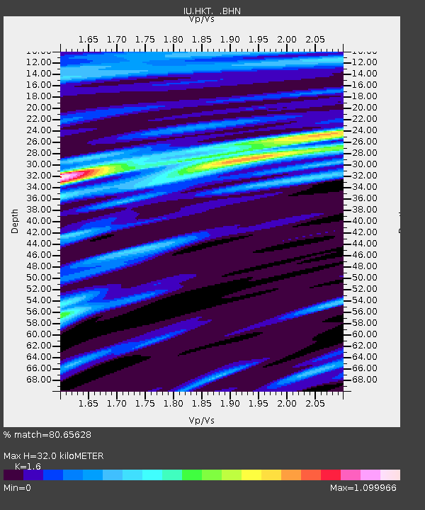
| Estimated Moho Depth: |
32.0 km |
| Estimated Crust Vp/Vs: |
1.60 |
| Assumed Crust Vp: |
5.581 km/s |
| Estimated Crust Vs: |
3.488 km/s |
| Estimated Crust Poisson's Ratio: |
0.18 |
|
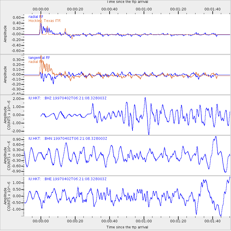
| Radial Match: |
80.65628 % |
| Radial Bump: |
397 |
| Transverse Match: |
61.13451 % |
| Transverse Bump: |
400 |
| SOD ConfigId: |
6273 |
| Insert Time: |
2010-03-02 13:53:00.704 +0000 |
| GWidth: |
2.5 |
| Max Bumps: |
400 |
| Tol: |
0.001 |
|
Signal To Noise
| Channel | StoN | STA | LTA |
| IU:HKT: :BHN:19970402T06:21:08.328003Z | 0.60873556 | 1.7921809E-7 | 2.9441043E-7 |
| IU:HKT: :BHE:19970402T06:21:08.328003Z | 1.351784 | 3.8433285E-7 | 2.843153E-7 |
| IU:HKT: :BHZ:19970402T06:21:08.328003Z | 3.1700191 | 6.267449E-7 | 1.9771012E-7 |
| Arrivals |
| Ps | 3.7 SECOND |
| PpPs | 14 SECOND |
| PsPs/PpSs | 18 SECOND |


