You are here: Home > Network List > TA - USArray Transportable Network (new EarthScope stations) Stations List
> Station N02D Trinity Center, CA, USA > Earthquake Result Viewer
N02D Trinity Center, CA, USA - Earthquake Result Viewer
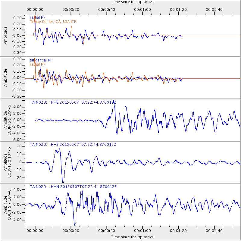
| Earthquake location: |
Solomon Islands |
| Earthquake latitude/longitude: |
-7.3/154.5 |
| Earthquake time(UTC): |
2015/05/07 (127) 07:10:22 GMT |
| Earthquake Depth: |
22 km |
| Earthquake Magnitude: |
7.2 MWP, 7.2 MI |
| Earthquake Catalog/Contributor: |
NEIC PDE/NEIC COMCAT |
|
| Network: |
TA USArray Transportable Network (new EarthScope stations) |
| Station: |
N02D Trinity Center, CA, USA |
| Lat/Lon: |
40.97 N/122.71 W |
| Elevation: |
937 m |
|
| Distance: |
89.3 deg |
| Az: |
48.695 deg |
| Baz: |
259.808 deg |
| Ray Param: |
0.04194052 |
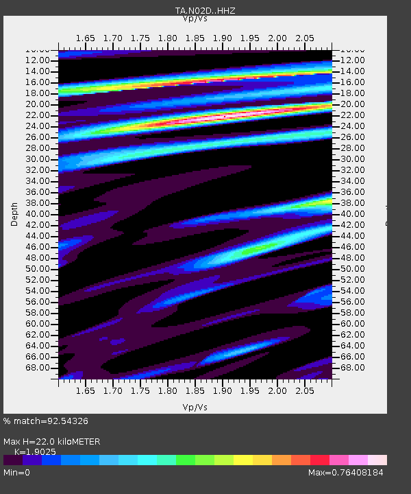
| Estimated Moho Depth: |
22.0 km |
| Estimated Crust Vp/Vs: |
1.90 |
| Assumed Crust Vp: |
6.566 km/s |
| Estimated Crust Vs: |
3.451 km/s |
| Estimated Crust Poisson's Ratio: |
0.31 |
|
| Radial Match: |
92.54326 % |
| Radial Bump: |
400 |
| Transverse Match: |
87.243034 % |
| Transverse Bump: |
292 |
| SOD ConfigId: |
7422571 |
| Insert Time: |
2019-04-18 17:24:45.563 +0000 |
| GWidth: |
2.5 |
| Max Bumps: |
400 |
| Tol: |
0.001 |
|
Signal To Noise
| Channel | StoN | STA | LTA |
| TA:N02D: :HHZ:20150507T07:22:44.870012Z | 5.293347 | 5.460559E-7 | 1.0315891E-7 |
| TA:N02D: :HHN:20150507T07:22:44.870012Z | 1.8734224 | 3.871783E-7 | 2.0666897E-7 |
| TA:N02D: :HHE:20150507T07:22:44.870012Z | 1.5384669 | 2.068414E-7 | 1.3444644E-7 |
| Arrivals |
| Ps | 3.1 SECOND |
| PpPs | 9.5 SECOND |
| PsPs/PpSs | 13 SECOND |


