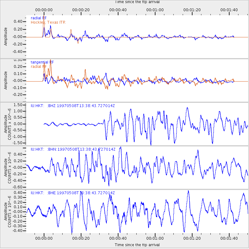
HKT Hockley, Texas - Earthquake Result Viewer
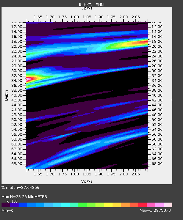
Earthquake location: Fox Islands, Aleutian Islands
Earthquake latitude/longitude: 51.7/-170.8
Earthquake time(UTC): 1997/05/08 (128) 13:29:24 GMT
Earthquake Depth: 33 km
Earthquake Magnitude: 5.8 MB, 5.9 MS, 6.0 UNKNOWN, 6.0 MW
Earthquake Catalog/Contributor: WHDF/NEIC
Network: IU Global Seismograph Network (GSN - IRIS/USGS)
Station: HKT Hockley, Texas
Lat/Lon: 29.96 N/95.84 W
Elevation: -413.0 m
Distance: 58.1 deg
Az: 80.994 deg
Baz: 314.924 deg
Ray Param: 0.06303755
Estimated Moho Depth: 33.25 km
Estimated Crust Vp/Vs: 1.60
Assumed Crust Vp: 5.581 km/s
Estimated Crust Vs: 3.488 km/s
Estimated Crust Poisson's Ratio: 0.18
Radial Match: 87.64856 %
Radial Bump: 399
Transverse Match: 55.62531 %
Transverse Bump: 380
SOD ConfigId: 6273
Insert Time: 2010-03-02 13:53:05.833 +0000
GWidth: 2.5
Max Bumps: 400
Tol: 0.001

Signal To Noise

ChannelStoNSTALTA
IU:HKT: :BHN:19970508T13:38:43.727014Z2.39370851.2656955E-75.2875922E-8
IU:HKT: :BHE:19970508T13:38:43.727014Z0.92769186.527794E-87.036597E-8
IU:HKT: :BHZ:19970508T13:38:43.727014Z6.55629734.185336E-76.3836886E-8
Arrivals
Ps3.7 SECOND
PpPs15 SECOND
PsPs/PpSs19 SECOND