You are here: Home > Network List > IU - Global Seismograph Network (GSN - IRIS/USGS) Stations List
> Station HKT Hockley, Texas > Earthquake Result Viewer
HKT Hockley, Texas - Earthquake Result Viewer
| Earthquake location: |
Southern Pacific Ocean |
| Earthquake latitude/longitude: |
-36.0/-102.5 |
| Earthquake time(UTC): |
1997/05/29 (149) 17:02:38 GMT |
| Earthquake Depth: |
10 km |
| Earthquake Magnitude: |
5.6 MB, 6.1 MS, 6.5 UNKNOWN, 6.4 MW |
| Earthquake Catalog/Contributor: |
WHDF/NEIC |
|
| Network: |
IU Global Seismograph Network (GSN - IRIS/USGS) |
| Station: |
HKT Hockley, Texas |
| Lat/Lon: |
29.96 N/95.84 W |
| Elevation: |
-413.0 m |
|
| Distance: |
65.9 deg |
| Az: |
6.343 deg |
| Baz: |
185.928 deg |
| Ray Param: |
0.05798385 |
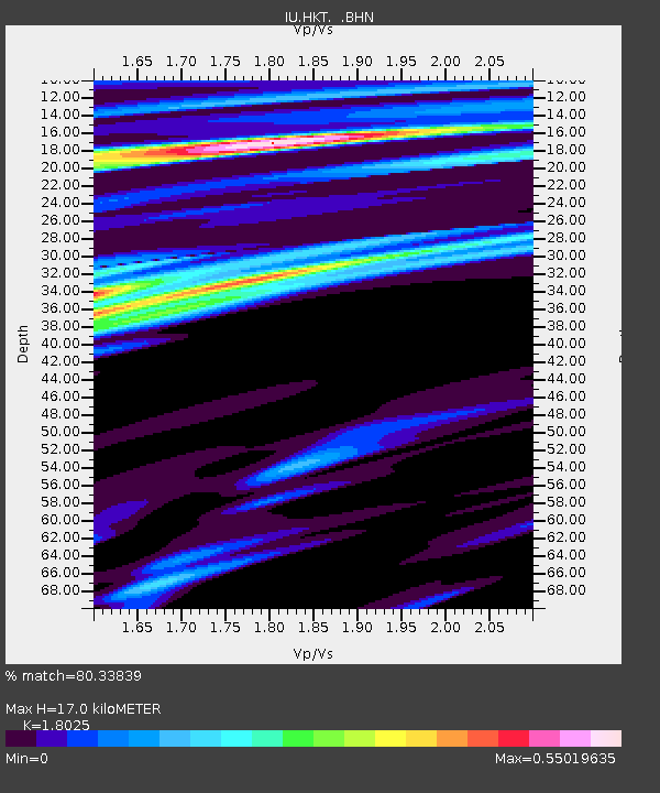
| Estimated Moho Depth: |
17.0 km |
| Estimated Crust Vp/Vs: |
1.80 |
| Assumed Crust Vp: |
5.581 km/s |
| Estimated Crust Vs: |
3.097 km/s |
| Estimated Crust Poisson's Ratio: |
0.28 |
|
| Radial Match: |
80.33839 % |
| Radial Bump: |
311 |
| Transverse Match: |
76.34974 % |
| Transverse Bump: |
400 |
| SOD ConfigId: |
6273 |
| Insert Time: |
2010-03-02 13:53:10.332 +0000 |
| GWidth: |
2.5 |
| Max Bumps: |
400 |
| Tol: |
0.001 |
|
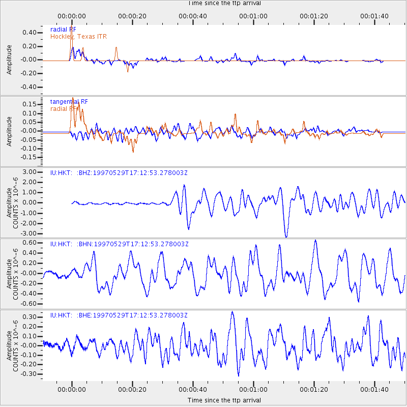
Signal To Noise
| Channel | StoN | STA | LTA |
| IU:HKT: :BHN:19970529T17:12:53.278003Z | 1.0428598 | 9.017958E-8 | 8.647336E-8 |
| IU:HKT: :BHE:19970529T17:12:53.278003Z | 1.092335 | 6.105974E-8 | 5.5898365E-8 |
| IU:HKT: :BHZ:19970529T17:12:53.278003Z | 6.8071575 | 4.781384E-7 | 7.024054E-8 |
| Arrivals |
| Ps | 2.5 SECOND |
| PpPs | 8.3 SECOND |
| PsPs/PpSs | 11 SECOND |


