You are here: Home > Network List > TJ - Tajikistan National Seismic Network Stations List
> Station MANEM Manem, Tajikistan > Earthquake Result Viewer
MANEM Manem, Tajikistan - Earthquake Result Viewer
| Earthquake location: |
Solomon Islands |
| Earthquake latitude/longitude: |
-7.3/154.5 |
| Earthquake time(UTC): |
2015/05/07 (127) 07:10:22 GMT |
| Earthquake Depth: |
22 km |
| Earthquake Magnitude: |
7.2 MWP, 7.2 MI |
| Earthquake Catalog/Contributor: |
NEIC PDE/NEIC COMCAT |
|
| Network: |
TJ Tajikistan National Seismic Network |
| Station: |
MANEM Manem, Tajikistan |
| Lat/Lon: |
37.53 N/71.66 E |
| Elevation: |
2312 m |
|
| Distance: |
88.8 deg |
| Az: |
307.903 deg |
| Baz: |
100.063 deg |
| Ray Param: |
0.04231928 |
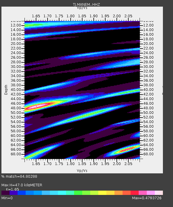
| Estimated Moho Depth: |
47.0 km |
| Estimated Crust Vp/Vs: |
1.65 |
| Assumed Crust Vp: |
6.306 km/s |
| Estimated Crust Vs: |
3.822 km/s |
| Estimated Crust Poisson's Ratio: |
0.21 |
|
| Radial Match: |
84.80288 % |
| Radial Bump: |
400 |
| Transverse Match: |
72.61121 % |
| Transverse Bump: |
400 |
| SOD ConfigId: |
7422571 |
| Insert Time: |
2019-04-18 17:24:56.909 +0000 |
| GWidth: |
2.5 |
| Max Bumps: |
400 |
| Tol: |
0.001 |
|

Signal To Noise
| Channel | StoN | STA | LTA |
| TJ:MANEM: :HHZ:20150507T07:22:42.599993Z | 8.766211 | 8.157554E-7 | 9.305679E-8 |
| TJ:MANEM: :HHN:20150507T07:22:42.599993Z | 0.7445854 | 8.49923E-8 | 1.1414715E-7 |
| TJ:MANEM: :HHE:20150507T07:22:42.599993Z | 2.417634 | 2.1594913E-7 | 8.9322505E-8 |
| Arrivals |
| Ps | 5.0 SECOND |
| PpPs | 19 SECOND |
| PsPs/PpSs | 24 SECOND |


