You are here: Home > Network List > TO - Tectonic Observatory Stations List
> Station CC31 CCSE CC31 > Earthquake Result Viewer
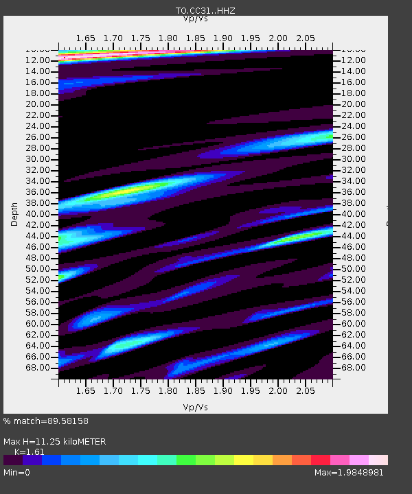
CC31 CCSE CC31 - Earthquake Result Viewer
| Earthquake location: |
Solomon Islands |
| Earthquake latitude/longitude: |
-7.3/154.5 |
| Earthquake time(UTC): |
2015/05/07 (127) 07:10:22 GMT |
| Earthquake Depth: |
22 km |
| Earthquake Magnitude: |
7.2 MWP, 7.2 MI |
| Earthquake Catalog/Contributor: |
NEIC PDE/NEIC COMCAT |
|
| Network: |
TO Tectonic Observatory |
| Station: |
CC31 CCSE CC31 |
| Lat/Lon: |
36.32 N/119.27 W |
| Elevation: |
93 m |
|
| Distance: |
91.2 deg |
| Az: |
53.709 deg |
| Baz: |
261.922 deg |
| Ray Param: |
0.04161687 |
| Estimated Moho Depth: |
11.25 km |
| Estimated Crust Vp/Vs: |
1.61 |
| Assumed Crust Vp: |
6.291 km/s |
| Estimated Crust Vs: |
3.908 km/s |
| Estimated Crust Poisson's Ratio: |
0.19 |
|
| Radial Match: |
89.58158 % |
| Radial Bump: |
400 |
| Transverse Match: |
89.58156 % |
| Transverse Bump: |
400 |
| SOD ConfigId: |
7422571 |
| Insert Time: |
2019-04-18 17:25:16.474 +0000 |
| GWidth: |
2.5 |
| Max Bumps: |
400 |
| Tol: |
0.001 |
|

Signal To Noise
| Channel | StoN | STA | LTA |
| TO:CC31: :HHZ:20150507T07:22:53.729998Z | 4.7036457 | 1.1703239E-6 | 2.4881209E-7 |
| $trig.getChannelId() | $trig.getValue() | $trig.getSTA() | $trig.getLTA() |
| TO:CC31: :HHE:20150507T07:22:53.729998Z | 1.7329642 | 8.305227E-7 | 4.7924976E-7 |
| Arrivals |
| Ps | 1.1 SECOND |
| PpPs | 4.6 SECOND |
| PsPs/PpSs | 5.7 SECOND |


