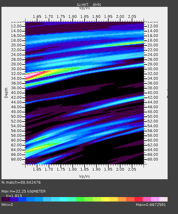
HKT Hockley, Texas - Earthquake Result Viewer
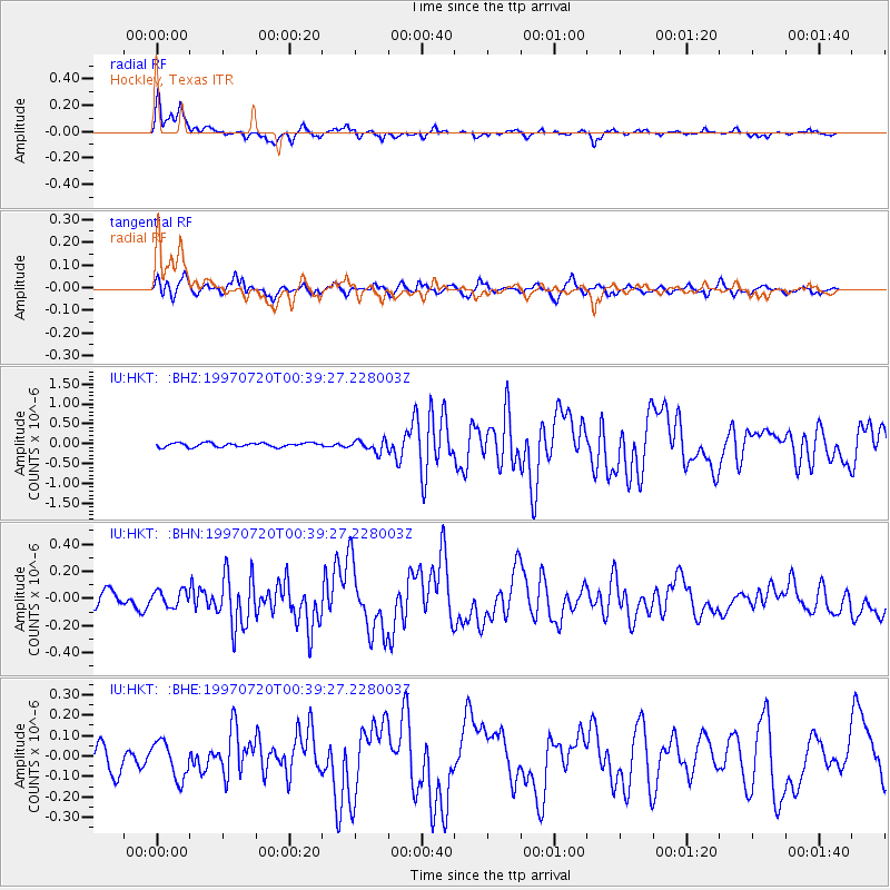
Earthquake location: Fox Islands, Aleutian Islands
Earthquake latitude/longitude: 52.6/-167.5
Earthquake time(UTC): 1997/07/20 (201) 00:30:20 GMT
Earthquake Depth: 14 km
Earthquake Magnitude: 5.6 MB, 5.9 MS, 6.2 UNKNOWN, 6.2 MW
Earthquake Catalog/Contributor: WHDF/NEIC
Network: IU Global Seismograph Network (GSN - IRIS/USGS)
Station: HKT Hockley, Texas
Lat/Lon: 29.96 N/95.84 W
Elevation: -413.0 m
Distance: 55.9 deg
Az: 83.976 deg
Baz: 315.606 deg
Ray Param: 0.06447163
Estimated Moho Depth: 32.25 km
Estimated Crust Vp/Vs: 1.62
Assumed Crust Vp: 5.581 km/s
Estimated Crust Vs: 3.456 km/s
Estimated Crust Poisson's Ratio: 0.19
Radial Match: 88.842476 %
Radial Bump: 353
Transverse Match: 75.90861 %
Transverse Bump: 383
SOD ConfigId: 6273
Insert Time: 2010-03-02 13:53:21.152 +0000
GWidth: 2.5
Max Bumps: 400
Tol: 0.001

Signal To Noise

ChannelStoNSTALTA
IU:HKT: :BHN:19970720T00:39:27.228003Z1.34907226.113955E-84.5319705E-8
IU:HKT: :BHE:19970720T00:39:27.228003Z1.68216099.147731E-85.4380834E-8
IU:HKT: :BHZ:19970720T00:39:27.228003Z2.85380131.43205E-75.018044E-8
Arrivals
Ps3.7 SECOND
PpPs14 SECOND
PsPs/PpSs18 SECOND