You are here: Home > Network List > TO - Tectonic Observatory Stations List
> Station CC33 CCSE CC33 > Earthquake Result Viewer
CC33 CCSE CC33 - Earthquake Result Viewer
| Earthquake location: |
Solomon Islands |
| Earthquake latitude/longitude: |
-7.3/154.5 |
| Earthquake time(UTC): |
2015/05/07 (127) 07:10:22 GMT |
| Earthquake Depth: |
22 km |
| Earthquake Magnitude: |
7.2 MWP, 7.2 MI |
| Earthquake Catalog/Contributor: |
NEIC PDE/NEIC COMCAT |
|
| Network: |
TO Tectonic Observatory |
| Station: |
CC33 CCSE CC33 |
| Lat/Lon: |
36.34 N/119.12 W |
| Elevation: |
126 m |
|
| Distance: |
91.3 deg |
| Az: |
53.701 deg |
| Baz: |
262.012 deg |
| Ray Param: |
0.04160796 |
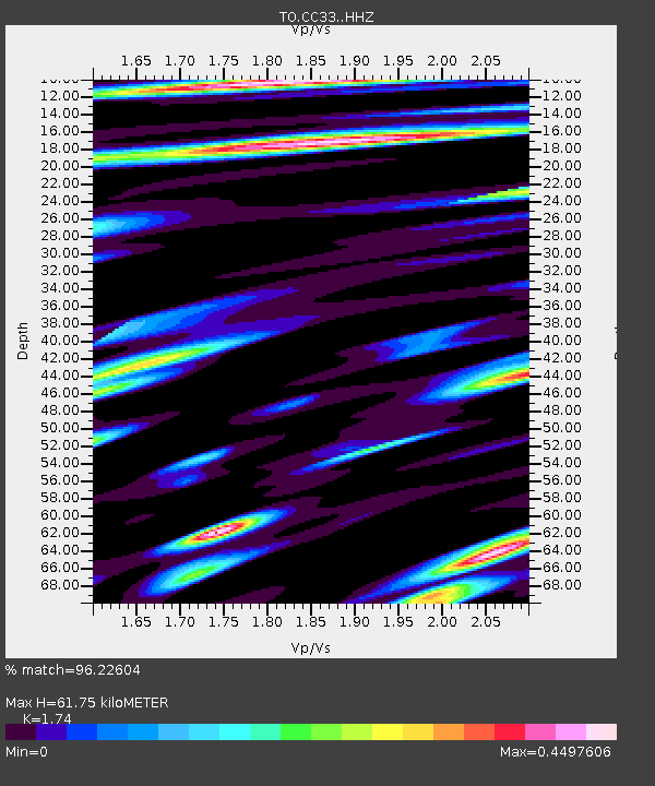
| Estimated Moho Depth: |
61.75 km |
| Estimated Crust Vp/Vs: |
1.74 |
| Assumed Crust Vp: |
6.291 km/s |
| Estimated Crust Vs: |
3.616 km/s |
| Estimated Crust Poisson's Ratio: |
0.25 |
|
| Radial Match: |
96.22604 % |
| Radial Bump: |
321 |
| Transverse Match: |
82.646675 % |
| Transverse Bump: |
400 |
| SOD ConfigId: |
7422571 |
| Insert Time: |
2019-04-18 17:25:17.173 +0000 |
| GWidth: |
2.5 |
| Max Bumps: |
400 |
| Tol: |
0.001 |
|

Signal To Noise
| Channel | StoN | STA | LTA |
| TO:CC33: :HHZ:20150507T07:22:54.310015Z | 7.8927355 | 1.1219076E-6 | 1.4214433E-7 |
| TO:CC33: :HHN:20150507T07:22:54.310015Z | 0.9453582 | 2.0500416E-7 | 2.1685342E-7 |
| TO:CC33: :HHE:20150507T07:22:54.310015Z | 2.895785 | 5.12389E-7 | 1.7694305E-7 |
| Arrivals |
| Ps | 7.4 SECOND |
| PpPs | 26 SECOND |
| PsPs/PpSs | 34 SECOND |


