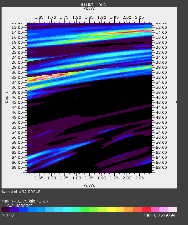
HKT Hockley, Texas - Earthquake Result Viewer
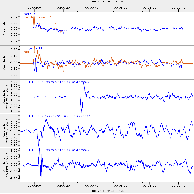
Earthquake location: Jujuy Province, Argentina
Earthquake latitude/longitude: -23.0/-66.3
Earthquake time(UTC): 1997/07/20 (201) 10:14:22 GMT
Earthquake Depth: 256 km
Earthquake Magnitude: 5.7 MB, 6.1 UNKNOWN, 5.7 ME
Earthquake Catalog/Contributor: WHDF/NEIC
Network: IU Global Seismograph Network (GSN - IRIS/USGS)
Station: HKT Hockley, Texas
Lat/Lon: 29.96 N/95.84 W
Elevation: -413.0 m
Distance: 59.8 deg
Az: 330.333 deg
Baz: 148.29 deg
Ray Param: 0.061087105
Estimated Moho Depth: 31.75 km
Estimated Crust Vp/Vs: 1.68
Assumed Crust Vp: 5.581 km/s
Estimated Crust Vs: 3.322 km/s
Estimated Crust Poisson's Ratio: 0.23
Radial Match: 84.09348 %
Radial Bump: 400
Transverse Match: 71.78508 %
Transverse Bump: 400
SOD ConfigId: 6273
Insert Time: 2010-03-02 13:53:23.922 +0000
GWidth: 2.5
Max Bumps: 400
Tol: 0.001

Signal To Noise

ChannelStoNSTALTA
IU:HKT: :BHN:19970720T10:23:30.477002Z4.8498623.5307744E-77.280154E-8
IU:HKT: :BHE:19970720T10:23:30.477002Z6.03302055.0687436E-78.4016676E-8
IU:HKT: :BHZ:19970720T10:23:30.477002Z22.232562.2317972E-61.0038418E-7
Arrivals
Ps4.0 SECOND
PpPs15 SECOND
PsPs/PpSs19 SECOND