You are here: Home > Network List > UW - Pacific Northwest Regional Seismic Network Stations List
> Station DAVN Chrisman Ranch, Davenport, WA, USA > Earthquake Result Viewer
DAVN Chrisman Ranch, Davenport, WA, USA - Earthquake Result Viewer
| Earthquake location: |
Solomon Islands |
| Earthquake latitude/longitude: |
-7.3/154.5 |
| Earthquake time(UTC): |
2015/05/07 (127) 07:10:22 GMT |
| Earthquake Depth: |
22 km |
| Earthquake Magnitude: |
7.2 MWP, 7.2 MI |
| Earthquake Catalog/Contributor: |
NEIC PDE/NEIC COMCAT |
|
| Network: |
UW Pacific Northwest Regional Seismic Network |
| Station: |
DAVN Chrisman Ranch, Davenport, WA, USA |
| Lat/Lon: |
47.80 N/118.27 W |
| Elevation: |
495 m |
|
| Distance: |
93.4 deg |
| Az: |
42.423 deg |
| Baz: |
263.053 deg |
| Ray Param: |
0.04125304 |
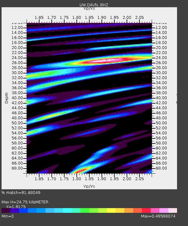
| Estimated Moho Depth: |
24.75 km |
| Estimated Crust Vp/Vs: |
1.92 |
| Assumed Crust Vp: |
6.419 km/s |
| Estimated Crust Vs: |
3.348 km/s |
| Estimated Crust Poisson's Ratio: |
0.31 |
|
| Radial Match: |
91.68049 % |
| Radial Bump: |
400 |
| Transverse Match: |
85.44793 % |
| Transverse Bump: |
400 |
| SOD ConfigId: |
7422571 |
| Insert Time: |
2019-04-18 17:25:38.525 +0000 |
| GWidth: |
2.5 |
| Max Bumps: |
400 |
| Tol: |
0.001 |
|
Signal To Noise
| Channel | StoN | STA | LTA |
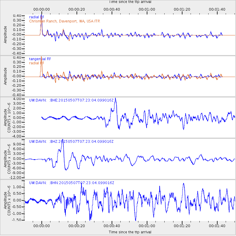
| UW:DAVN: :BHZ:20150507T07:23:04.099016Z | 3.220458 | 4.915349E-7 | 1.5262887E-7 |
| UW:DAVN: :BHN:20150507T07:23:04.099016Z | 0.82622105 | 9.5700585E-8 | 1.1582928E-7 |
| UW:DAVN: :BHE:20150507T07:23:04.099016Z | 0.97108 | 2.0012193E-7 | 2.0608182E-7 |
| Arrivals |
| Ps | 3.6 SECOND |
| PpPs | 11 SECOND |
| PsPs/PpSs | 15 SECOND |


