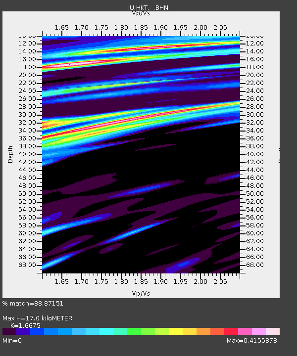
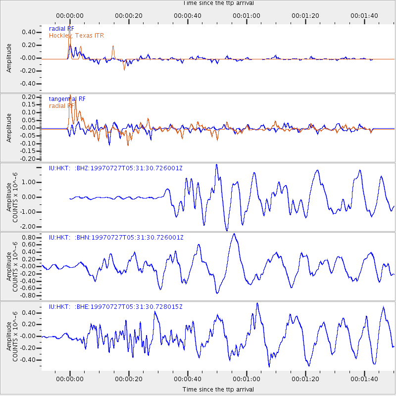
HKT Hockley, Texas - Earthquake Result Viewer

Earthquake location: Near Coast Of Central Chile
Earthquake latitude/longitude: -30.5/-71.9
Earthquake time(UTC): 1997/07/27 (208) 05:21:29 GMT
Earthquake Depth: 33 km
Earthquake Magnitude: 5.6 MB, 5.8 MS, 6.3 UNKNOWN, 6.2 MW
Earthquake Catalog/Contributor: WHDF/NEIC
Network: IU Global Seismograph Network (GSN - IRIS/USGS)
Station: HKT Hockley, Texas
Lat/Lon: 29.96 N/95.84 W
Elevation: -413.0 m
Distance: 64.3 deg
Az: 336.967 deg
Baz: 157.103 deg
Ray Param: 0.058939025
Estimated Moho Depth: 17.0 km
Estimated Crust Vp/Vs: 1.67
Assumed Crust Vp: 5.581 km/s
Estimated Crust Vs: 3.347 km/s
Estimated Crust Poisson's Ratio: 0.22
Radial Match: 88.87151 %
Radial Bump: 301
Transverse Match: 81.7542 %
Transverse Bump: 400
SOD ConfigId: 6273
Insert Time: 2010-03-02 13:53:27.395 +0000
GWidth: 2.5
Max Bumps: 400
Tol: 0.001

Signal To Noise

ChannelStoNSTALTA
IU:HKT: :BHN:19970727T05:31:30.726001Z1.71529846.484184E-83.7802074E-8
IU:HKT: :BHE:19970727T05:31:30.728015Z0.880341233.9637502E-84.5025157E-8
IU:HKT: :BHZ:19970727T05:31:30.726001Z6.02276043.2281443E-75.3599084E-8
Arrivals
Ps2.1 SECOND
PpPs7.9 SECOND
PsPs/PpSs10.0 SECOND