You are here: Home > Network List > UW - Pacific Northwest Regional Seismic Network Stations List
> Station MRBL Marblemount, WA, USA > Earthquake Result Viewer
MRBL Marblemount, WA, USA - Earthquake Result Viewer
| Earthquake location: |
Solomon Islands |
| Earthquake latitude/longitude: |
-7.3/154.5 |
| Earthquake time(UTC): |
2015/05/07 (127) 07:10:22 GMT |
| Earthquake Depth: |
22 km |
| Earthquake Magnitude: |
7.2 MWP, 7.2 MI |
| Earthquake Catalog/Contributor: |
NEIC PDE/NEIC COMCAT |
|
| Network: |
UW Pacific Northwest Regional Seismic Network |
| Station: |
MRBL Marblemount, WA, USA |
| Lat/Lon: |
48.52 N/121.48 W |
| Elevation: |
75 m |
|
| Distance: |
91.4 deg |
| Az: |
41.408 deg |
| Baz: |
260.711 deg |
| Ray Param: |
0.04160115 |
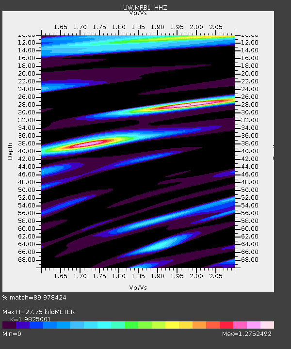
| Estimated Moho Depth: |
27.75 km |
| Estimated Crust Vp/Vs: |
1.98 |
| Assumed Crust Vp: |
6.566 km/s |
| Estimated Crust Vs: |
3.312 km/s |
| Estimated Crust Poisson's Ratio: |
0.33 |
|
| Radial Match: |
89.978424 % |
| Radial Bump: |
400 |
| Transverse Match: |
84.96743 % |
| Transverse Bump: |
400 |
| SOD ConfigId: |
7422571 |
| Insert Time: |
2019-04-18 17:25:50.168 +0000 |
| GWidth: |
2.5 |
| Max Bumps: |
400 |
| Tol: |
0.001 |
|
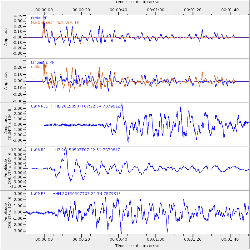
Signal To Noise
| Channel | StoN | STA | LTA |
| UW:MRBL: :HHZ:20150507T07:22:54.787981Z | 5.389839 | 4.354105E-7 | 8.078358E-8 |
| UW:MRBL: :HHN:20150507T07:22:54.787981Z | 1.1120547 | 1.2457183E-7 | 1.12019514E-7 |
| UW:MRBL: :HHE:20150507T07:22:54.787981Z | 2.6358209 | 2.0386953E-7 | 7.7345746E-8 |
| Arrivals |
| Ps | 4.2 SECOND |
| PpPs | 12 SECOND |
| PsPs/PpSs | 17 SECOND |


