You are here: Home > Network List > XD14 - Illuminating the architecture of the greater Mount St. Helens magmatic systems f Stations List
> Station ME03 "Mount St Helens, WA" > Earthquake Result Viewer
ME03 "Mount St Helens, WA" - Earthquake Result Viewer
| Earthquake location: |
Solomon Islands |
| Earthquake latitude/longitude: |
-7.3/154.5 |
| Earthquake time(UTC): |
2015/05/07 (127) 07:10:22 GMT |
| Earthquake Depth: |
22 km |
| Earthquake Magnitude: |
7.2 MWP, 7.2 MI |
| Earthquake Catalog/Contributor: |
NEIC PDE/NEIC COMCAT |
|
| Network: |
XD Illuminating the architecture of the greater Mount St. Helens magmatic systems f |
| Station: |
ME03 "Mount St Helens, WA" |
| Lat/Lon: |
46.45 N/122.58 W |
| Elevation: |
310 m |
|
| Distance: |
90.3 deg |
| Az: |
43.321 deg |
| Baz: |
259.879 deg |
| Ray Param: |
0.041678082 |
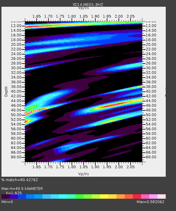
| Estimated Moho Depth: |
48.5 km |
| Estimated Crust Vp/Vs: |
1.62 |
| Assumed Crust Vp: |
6.566 km/s |
| Estimated Crust Vs: |
4.041 km/s |
| Estimated Crust Poisson's Ratio: |
0.20 |
|
| Radial Match: |
90.42762 % |
| Radial Bump: |
400 |
| Transverse Match: |
75.888626 % |
| Transverse Bump: |
400 |
| SOD ConfigId: |
7422571 |
| Insert Time: |
2019-04-18 17:26:07.626 +0000 |
| GWidth: |
2.5 |
| Max Bumps: |
400 |
| Tol: |
0.001 |
|

Signal To Noise
| Channel | StoN | STA | LTA |
| XD:ME03: :BHZ:20150507T07:22:49.795Z | 2.2844563 | 5.8941436E-7 | 2.5801077E-7 |
| XD:ME03: :BHN:20150507T07:22:49.795Z | 1.2138638 | 1.3862197E-7 | 1.1419895E-7 |
| XD:ME03: :BHE:20150507T07:22:49.795Z | 2.0029461 | 2.8572768E-7 | 1.4265369E-7 |
| Arrivals |
| Ps | 4.7 SECOND |
| PpPs | 19 SECOND |
| PsPs/PpSs | 24 SECOND |


