You are here: Home > Network List > IU - Global Seismograph Network (GSN - IRIS/USGS) Stations List
> Station HKT Hockley, Texas > Earthquake Result Viewer
HKT Hockley, Texas - Earthquake Result Viewer
| Earthquake location: |
Leeward Islands |
| Earthquake latitude/longitude: |
15.8/-61.7 |
| Earthquake time(UTC): |
2005/02/14 (045) 18:05:59 GMT |
| Earthquake Depth: |
12 km |
| Earthquake Magnitude: |
5.6 MB, 5.5 MS, 5.9 MW, 5.9 MW |
| Earthquake Catalog/Contributor: |
WHDF/NEIC |
|
| Network: |
IU Global Seismograph Network (GSN - IRIS/USGS) |
| Station: |
HKT Hockley, Texas |
| Lat/Lon: |
29.96 N/95.84 W |
| Elevation: |
-413.0 m |
|
| Distance: |
34.3 deg |
| Az: |
300.301 deg |
| Baz: |
106.682 deg |
| Ray Param: |
0.07781052 |
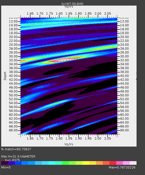
| Estimated Moho Depth: |
31.5 km |
| Estimated Crust Vp/Vs: |
1.84 |
| Assumed Crust Vp: |
5.581 km/s |
| Estimated Crust Vs: |
3.038 km/s |
| Estimated Crust Poisson's Ratio: |
0.29 |
|
| Radial Match: |
80.70637 % |
| Radial Bump: |
364 |
| Transverse Match: |
56.454536 % |
| Transverse Bump: |
400 |
| SOD ConfigId: |
2455 |
| Insert Time: |
2010-03-02 13:53:40.087 +0000 |
| GWidth: |
2.5 |
| Max Bumps: |
400 |
| Tol: |
0.001 |
|
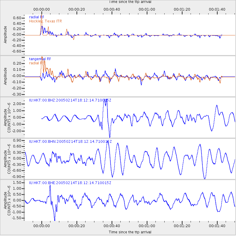
Signal To Noise
| Channel | StoN | STA | LTA |
| IU:HKT:00:BHN:20050214T18:12:14.710015Z | 0.76209384 | 2.0111794E-7 | 2.639018E-7 |
| IU:HKT:00:BHE:20050214T18:12:14.710015Z | 1.5854328 | 3.9807117E-7 | 2.5108045E-7 |
| IU:HKT:00:BHZ:20050214T18:12:14.710015Z | 2.5381856 | 6.680184E-7 | 2.6318736E-7 |
| Arrivals |
| Ps | 5.0 SECOND |
| PpPs | 15 SECOND |
| PsPs/PpSs | 20 SECOND |


