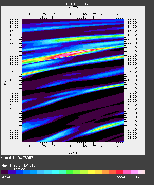
HKT Hockley, Texas - Earthquake Result Viewer
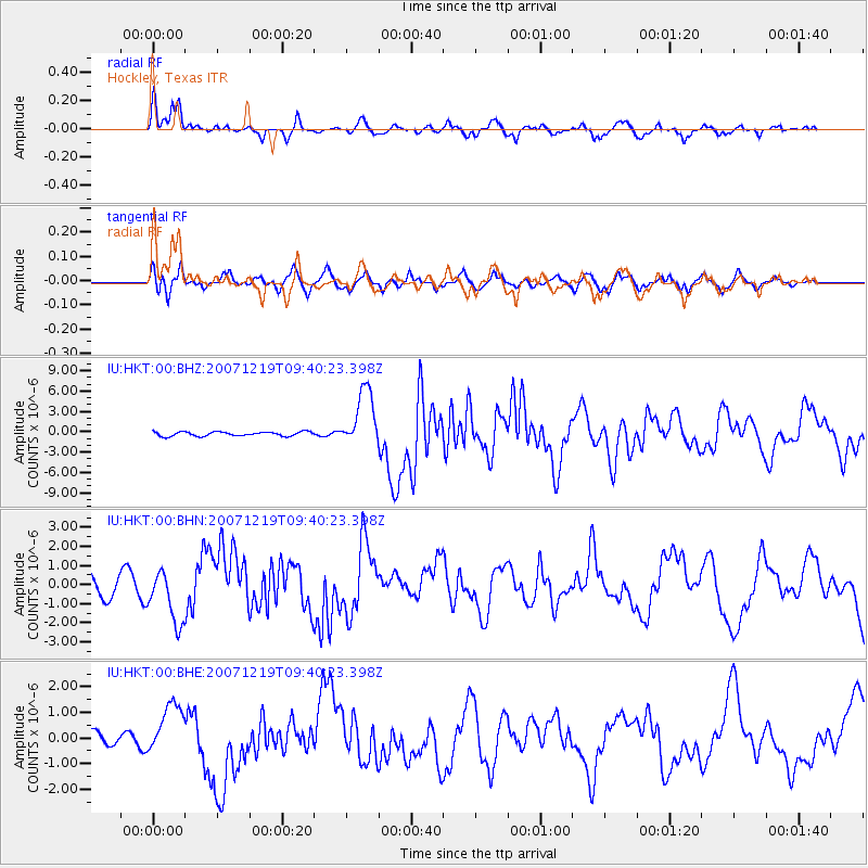
Earthquake location: Andreanof Islands, Aleutian Is.
Earthquake latitude/longitude: 51.4/-179.5
Earthquake time(UTC): 2007/12/19 (353) 09:30:27 GMT
Earthquake Depth: 29 km
Earthquake Magnitude: 6.4 MB, 7.1 MS, 7.1 MW, 7.0 MW
Earthquake Catalog/Contributor: WHDF/NEIC
Network: IU Global Seismograph Network (GSN - IRIS/USGS)
Station: HKT Hockley, Texas
Lat/Lon: 29.96 N/95.84 W
Elevation: -413.0 m
Distance: 63.4 deg
Az: 74.627 deg
Baz: 315.845 deg
Ray Param: 0.059524614
Estimated Moho Depth: 26.0 km
Estimated Crust Vp/Vs: 1.87
Assumed Crust Vp: 5.581 km/s
Estimated Crust Vs: 2.981 km/s
Estimated Crust Poisson's Ratio: 0.30
Radial Match: 86.75857 %
Radial Bump: 317
Transverse Match: 61.032288 %
Transverse Bump: 400
SOD ConfigId: 2564
Insert Time: 2010-03-02 13:53:42.890 +0000
GWidth: 2.5
Max Bumps: 400
Tol: 0.001

Signal To Noise

ChannelStoNSTALTA
IU:HKT:00:BHN:20071219T09:40:23.398Z1.92461171.423953E-67.398651E-7
IU:HKT:00:BHE:20071219T09:40:23.398Z3.00648861.0179306E-63.385779E-7
IU:HKT:00:BHZ:20071219T09:40:23.398Z13.4580184.285884E-63.1846326E-7
Arrivals
Ps4.2 SECOND
PpPs13 SECOND
PsPs/PpSs17 SECOND