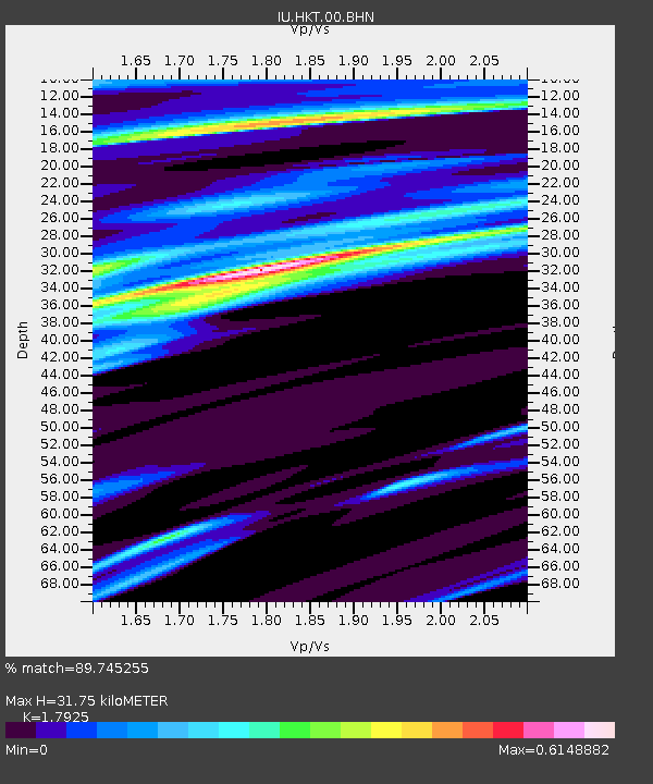
HKT Hockley, Texas - Earthquake Result Viewer
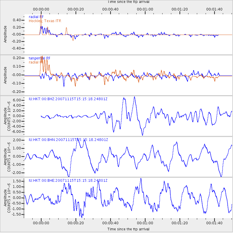
Earthquake location: Near Coast Of Northern Chile
Earthquake latitude/longitude: -22.9/-70.2
Earthquake time(UTC): 2007/11/15 (319) 15:05:58 GMT
Earthquake Depth: 26 km
Earthquake Magnitude: 6.1 MB, 6.6 MS, 6.8 MW, 6.6 MW
Earthquake Catalog/Contributor: WHDF/NEIC
Network: IU Global Seismograph Network (GSN - IRIS/USGS)
Station: HKT Hockley, Texas
Lat/Lon: 29.96 N/95.84 W
Elevation: -413.0 m
Distance: 58.1 deg
Az: 333.775 deg
Baz: 152.0 deg
Ray Param: 0.063053265
Estimated Moho Depth: 31.75 km
Estimated Crust Vp/Vs: 1.79
Assumed Crust Vp: 5.581 km/s
Estimated Crust Vs: 3.114 km/s
Estimated Crust Poisson's Ratio: 0.27
Radial Match: 89.745255 %
Radial Bump: 294
Transverse Match: 80.267845 %
Transverse Bump: 400
SOD ConfigId: 2564
Insert Time: 2010-03-02 13:53:47.874 +0000
GWidth: 2.5
Max Bumps: 400
Tol: 0.001

Signal To Noise

ChannelStoNSTALTA
IU:HKT:00:BHN:20071115T15:15:18.24801Z0.94193142.0628353E-72.1900058E-7
IU:HKT:00:BHE:20071115T15:15:18.24801Z0.820878861.7743662E-72.1615443E-7
IU:HKT:00:BHZ:20071115T15:15:18.24801Z2.03929116.680133E-73.275713E-7
Arrivals
Ps4.7 SECOND
PpPs15 SECOND
PsPs/PpSs20 SECOND